IMAGES TAKEN NEAR TO
Waters Reach, ASHTON-UNDER-LYNE, OL5 9FG
Introduction
This page details the photographs taken nearby to Waters Reach, OL5 9FG by members of the Geograph project.
The Geograph project started in 2005 with the aim of publishing, organising and preserving representative images for every square kilometre of Great Britain, Ireland and the Isle of Man.

There are currently over 7.5m images from over14,400 individuals and you can help contribute to the project by visiting https://www.geograph.org.uk
Image Map
Images are licensed for reuse under creativecommons.org/licenses/by-sa/2.0
Notes
- Clicking on the map will re-center to the selected point.
- The higher the marker number, the further away the image location is from the centre of the postcode.
Image Listing (77 Images Found)
Images are licensed for reuse under creativecommons.org/licenses/by-sa/2.0
Image
Details
Distance
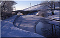
1
Slippage at Roaches
Someone's back garden has slipped onto the towpath.
Image: © Christine Johnstone
Taken: 18 May 2010
0.04 miles
2
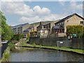
Huddersfield Narrow Canal, Lock 17W
The Huddersfield Narrow Canal runs for 20 miles between Huddersfield in West Yorkshire and Ashton under Lyne in Greater Manchester, UK. The summit of the Huddersfield Narrow Canal is the highest navigable waterway in Britain. Standedge Tunnel on the Huddersfield Narrow Canal is Britain's longest canal tunnel. The canal has a total of 74 locks. The Huddersfield Narrow Canal was fully opened in 1811 but was abandoned in the 1950s. It links the southern end of the Huddersfield Broad Canal, just north of Kings Mill, with the Ashton and Peak Forest Canals at Ashton under Lyne on the Lancashire side of the Pennines. The Huddersfield Narrow Canal re-opened to navigation in May 2001. http://www.penninewaterways.co.uk/index.htm
The Huddersfield Narrow Canal should not be confused with the Huddersfield Broad Canal which runs between the centre of Huddersfield and the Calder and Hebble Navigation at Cooper Bridge.
Image: © Richard Rogerson
Taken: 9 Jul 2017
0.04 miles
3
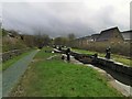
Lock 17W, Huddersfield Narrow Canal
At Roaches
Image: © Chris Morgan
Taken: 18 Mar 2019
0.05 miles
4
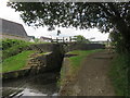
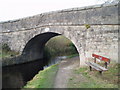
Division Bridge
This bridge over the Huddersfield Canal marks the present day boundary between Oldham and Tameside. The Roughtown area of Mossley is visible atop the hillside at right.
Image: © Michael Fox
Taken: 30 Dec 2000
0.06 miles
5
Division Bridge
Division Bridge crosses the Huddersfield Narrow Canal and separates Tameside MB from Oldham MB.
Image: © David Watson
Taken: 22 Oct 2007
0.07 miles
6
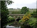
Royal George aqueduct
Carrying the Huddersfield Narrow Canal over the river Tame.
Image: © David Stowell
Taken: 13 Jun 2001
0.07 miles
7
![Mossley Footbridge [No. 86]](https://s0.geograph.org.uk/geophotos/01/88/04/1880436_f51606dd_120x120.jpg)
Mossley Footbridge [No. 86]
Like many smaller bridges on the Huddersfield Narrow Canal, this has been built into the tail of a lock.
Image: © Christine Johnstone
Taken: 18 May 2010
0.07 miles
8
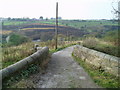
Division Bridge
Division Bridge carries the Oldham Way and Tameside Way footpaths over the Huddersfield Narrow Canal. It separates Tameside MB from Oldham MB.
Image: © David Watson
Taken: 22 Oct 2007
0.09 miles
9
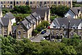
Spring Mill Drive
Housing development at The Roaches.
Image: © Peter McDermott
Taken: 2 Jul 2017
0.09 miles
10
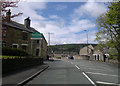
Welcome to Mossley: Welcome to Tameside
Along Manchester Road, at its junction with Shadows Lane, is the boundary between the Metropolitan Borough of Oldham and the Metropolitan Borough of Tameside, which in turn is the boundary between Saddleworth (specifically Greenfield) and Mossley respectively.
The boundary is marked by various welcome signage, including the one pictured here for both Mossley and Tameside.
Image: © Steven Haslington
Taken: 15 May 2012
0.09 miles