IMAGES TAKEN NEAR TO
Queen Street, ASHTON-UNDER-LYNE, OL5 9AL
Introduction
This page details the photographs taken nearby to Queen Street, OL5 9AL by members of the Geograph project.
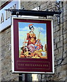
The Geograph project started in 2005 with the aim of publishing, organising and preserving representative images for every square kilometre of Great Britain, Ireland and the Isle of Man.

There are currently over 7.5m images from over14,400 individuals and you can help contribute to the project by visiting https://www.geograph.org.uk
Image Map
Images are licensed for reuse under creativecommons.org/licenses/by-sa/2.0
Notes
- Clicking on the map will re-center to the selected point.
- The higher the marker number, the further away the image location is from the centre of the postcode.
Image Listing (137 Images Found)
Images are licensed for reuse under creativecommons.org/licenses/by-sa/2.0
Image
Details
Distance
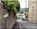
1
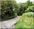
Queen Street
Leading up from the Two Mills area to Manchester Road.
Image: © Gerald England
Taken: 27 Jul 2010
0.03 miles
2
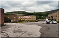
Queen Street Mills
Two old mills by the River Tame. One has already been converted into flats. Despite a large sign proclaiming Phase Two to be completed in 2009, the second mill appears to be still boarded up awaiting conversion.
Image: © Gerald England
Taken: 27 Jul 2010
0.03 miles
3
Queen Street Mills
One of the two mills at the bottom of Queen Street has been converted into apartments. Work on a second mill conversion appears to be at a standstill.
Image: © Gerald England
Taken: 27 Jul 2010
0.05 miles
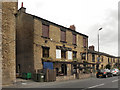
4
The Britannia Inn, Mossley
On Manchester Road (A635).
Image: © JThomas
Taken: 2 Nov 2018
0.07 miles
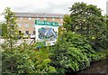
6
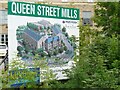
Queen Street Mills
Plans for the development at Queen Street Mills Image
Image: © Gerald England
Taken: 27 Jul 2010
0.07 miles
7
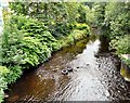
River Tame
Looking upstream from Waggon Lane bridge.
Image: © Gerald England
Taken: 27 Jul 2010
0.07 miles
8
Micklehurst Road
Between the bridges over the Huddersfield Narrow Canal and the River Tame at Bottoms.
Image: © Gerald England
Taken: 22 Jun 2009
0.07 miles
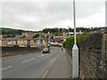
9
Mill Street
Leading down from Manchester Road to Bottoms.
Image: © Gerald England
Taken: 27 Jul 2010
0.08 miles
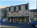
10
The Britannia Inn, Manchester Road, Mossley
Image: © David Dixon
Taken: 14 Jun 2011
0.08 miles