IMAGES TAKEN NEAR TO
Strawberry Lane, ASHTON-UNDER-LYNE, OL5 0RJ
Introduction
This page details the photographs taken nearby to Strawberry Lane, OL5 0RJ by members of the Geograph project.
The Geograph project started in 2005 with the aim of publishing, organising and preserving representative images for every square kilometre of Great Britain, Ireland and the Isle of Man.

There are currently over 7.5m images from over14,400 individuals and you can help contribute to the project by visiting https://www.geograph.org.uk
Image Map
Images are licensed for reuse under creativecommons.org/licenses/by-sa/2.0
Notes
- Clicking on the map will re-center to the selected point.
- The higher the marker number, the further away the image location is from the centre of the postcode.
Image Listing (37 Images Found)
Images are licensed for reuse under creativecommons.org/licenses/by-sa/2.0
Image
Details
Distance

2
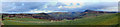
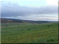
Panoramic View from Quick Edge
A wide angle view looking over the Tame Valley, towards the Pennine hills.
For closer views, see:
Image]
Image]
Image]
Image]
Image] and
Image]
Image: © David Dixon
Taken: 12 Dec 2011
0.07 miles
3
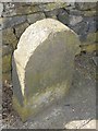
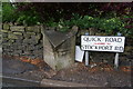
Old Milestone, A670, Stockport Road, South of Quick
The milestone is located just south of the junction with the A6050 Quick Road, set against the wall, on the west side of the road. Parish of Saddleworth (Oldham District). Stone post (plate lost), Brayshaw & Booth iron casting originally, erected by the County Council in the 19th century. Photograph taken sometime before April 2011.
Inscription once read:-
HUDDERSFIELD / 16 MILES / UPPERMILL / 2½ MILES : : STOCKPORT & ASHTON / ROAD / QUICK MERE LD : : MANCHESTER / 10 MILES / ASHTON / 3¾ MILES / MOSSLEY / ¼ MILE
Milestone Society National ID: YW_SRAS03
Image: © David Watson
Taken: Unknown
0.08 miles
4
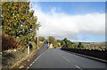
Stockport Road (A670)
Looking north towards the junction with the A6050.
Image: © JThomas
Taken: 2 Nov 2018
0.09 miles
5
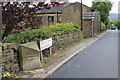
Boundary markers
This boundary stone was one of several which Mossley local authority commissioned in 1899; it was deliberately defaced during the 1939 to 1945 war. Behind is the modern sign denoting what is now the boundary between Tameside and Oldham.
Image: © Michael Fox
Taken: 9 Jun 2011
0.09 miles

7
Defaced boundary stone
Some local residents do not like certain local government reorganisation and boundary changes.
Image: © Bill Boaden
Taken: 29 May 2010
0.09 miles
8
View from Quick Edge (6)
Image: © David Dixon
Taken: 12 Dec 2011
0.09 miles
9
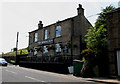
Mossley: The 'Rising Sun'
The boundary of the Borough of Mossley lies a short distance behind the photographer, and it is just outside this pub. that the SHMD Haddens tram terminus was situated. The pub itself is still open and has a wide choice of real ales, and a friendly welcoming atmosphere.
Image: © Dr Neil Clifton
Taken: 12 Jun 2015
0.09 miles
10
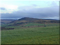
View from Quick Edge (5)
Image: © David Dixon
Taken: 12 Dec 2011
0.11 miles