IMAGES TAKEN NEAR TO
Athens Way, OLDHAM, OL4 3BP
Introduction
This page details the photographs taken nearby to Athens Way, OL4 3BP by members of the Geograph project.
The Geograph project started in 2005 with the aim of publishing, organising and preserving representative images for every square kilometre of Great Britain, Ireland and the Isle of Man.

There are currently over 7.5m images from over14,400 individuals and you can help contribute to the project by visiting https://www.geograph.org.uk
Image Map
Images are licensed for reuse under creativecommons.org/licenses/by-sa/2.0
Notes
- Clicking on the map will re-center to the selected point.
- The higher the marker number, the further away the image location is from the centre of the postcode.
Image Listing (45 Images Found)
Images are licensed for reuse under creativecommons.org/licenses/by-sa/2.0
Image
Details
Distance
1
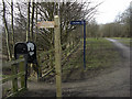
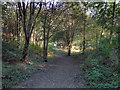
Medlock Valley Way, Bank Top
Looking west along the line of a disused railway that has now been converted to recreational use. The Medlock Valley Way heads left of shot towards Leesfield.
Image: © michael ely
Taken: 3 Mar 2010
0.06 miles
2
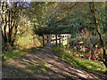
Wooden Bridge Over River medlock
The wooden bridge over the River Medlock at Leesbrook Nature Park.
Image: © David Dixon
Taken: 13 Oct 2011
0.08 miles
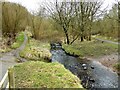
3
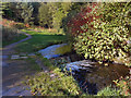
River Medlock Weir, Leesbrook
The weir on the River Medlock at Leesbrook Nature Park
Image: © David Dixon
Taken: 13 Oct 2011
0.09 miles
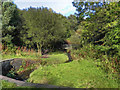
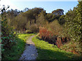
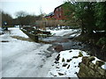
6
River Medlock at Lees
View on the Medlock Valley Way from a footbridge
Image: © Kevin Waterhouse
Taken: 10 Feb 2023
0.12 miles
8
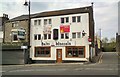
Balti Mossala
Restaurant on Lees High Street.
Image: © Gerald England
Taken: 2 May 2012
0.16 miles
9
Brookside as it fords the River Medlock
Image: © Alexander P Kapp
Taken: 12 Feb 2009
0.16 miles
10
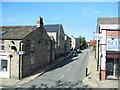
New Street, Lees/Oldham
Viewed from High Street A669.
Image: © John Topping
Taken: 28 Sep 2013
0.16 miles