IMAGES TAKEN NEAR TO
Higher Counthill, OLDHAM, OL4 2PZ
Introduction
This page details the photographs taken nearby to Higher Counthill, OL4 2PZ by members of the Geograph project.
The Geograph project started in 2005 with the aim of publishing, organising and preserving representative images for every square kilometre of Great Britain, Ireland and the Isle of Man.

There are currently over 7.5m images from over14,400 individuals and you can help contribute to the project by visiting https://www.geograph.org.uk
Image Map
Images are licensed for reuse under creativecommons.org/licenses/by-sa/2.0
Notes
- Clicking on the map will re-center to the selected point.
- The higher the marker number, the further away the image location is from the centre of the postcode.
Image Listing (18 Images Found)
Images are licensed for reuse under creativecommons.org/licenses/by-sa/2.0
Image
Details
Distance
1
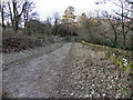
Medlock Valley Way
The Medlock Valley Way past the top of Strinesdale Upper Reservoir in the Strinesdale Country Park.
Image: © David Dixon
Taken: 28 Jan 2011
0.19 miles

3

Ripponden Road
New housing development off Ripponden Road in Oldham.
Image: © Peter McDermott
Taken: 2 Jul 2017
0.21 miles
4
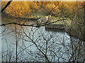
Strinesdale Upper Reservoir
The outlet at the southern end of Strinesdale Upper Reservoir, allowing the water to flow down to the lower reservoir.
Image: © David Dixon
Taken: 28 Jan 2011
0.21 miles
5

The Highfield
The Highfield public house.
Image: © Peter McDermott
Taken: 2 Jul 2017
0.22 miles
6

The Highfield public house
On Ripponden Road.
Image: © JThomas
Taken: 14 Mar 2015
0.22 miles
7
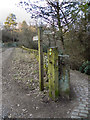
Medlock Valley Way
The Medlock Valley Way in the Strinesdale Country Park. The lower path (to the left) drops down to the Strinesdale Lower Reservoir whilst the top path passes the upper reservoir.
Image: © David Dixon
Taken: 28 Jan 2011
0.22 miles
9
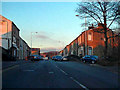
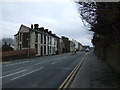
Ripponden Road (A672), Moorside
Ripponden Road, between Wilkes Street and Alexandra Terrace, Moorside.
Image: © David Dixon
Taken: 28 Jan 2011
0.22 miles
10

The Highfield, Ripponden Road, Moorside
Image: © Alexander P Kapp
Taken: 22 Nov 2012
0.23 miles