IMAGES TAKEN NEAR TO
Manchester Road, OLDHAM, OL3 7ES
Introduction
This page details the photographs taken nearby to Manchester Road, OL3 7ES by members of the Geograph project.
The Geograph project started in 2005 with the aim of publishing, organising and preserving representative images for every square kilometre of Great Britain, Ireland and the Isle of Man.

There are currently over 7.5m images from over14,400 individuals and you can help contribute to the project by visiting https://www.geograph.org.uk
Image Map
Images are licensed for reuse under creativecommons.org/licenses/by-sa/2.0
Notes
- Clicking on the map will re-center to the selected point.
- The higher the marker number, the further away the image location is from the centre of the postcode.
Image Listing (61 Images Found)
Images are licensed for reuse under creativecommons.org/licenses/by-sa/2.0
Image
Details
Distance
1
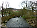
Ladhill Bridge, Greenfield
Chew Brook and Ladhill Bridge, Greenfield, Saddleworth, with Alphin Pike in the distance.
Image: © Carroll Pierce
Taken: 6 Apr 2014
0.10 miles
2
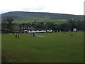
Greenfield Cricket Club
Juniors practising at Greenfield CC's Ladhill Lane ground.
The summit of Alphin can be seen in the background.
Image: © BatAndBall
Taken: 10 Jul 2011
0.11 miles
4
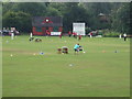
Greenfield Cricket Club - Changing Rooms
Greenfield CC play in the Saddleworth & District League.
Image: © BatAndBall
Taken: 10 Jul 2011
0.12 miles
5
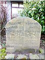
Old Boundary Marker by the A669, Chew Valley Road, Greenfield
Municipal Boundary Marker by the A669, in parish of Saddleworth (Oldham District), Chew Valley Road, Greenfield, South of junction with Grove Street, opposite No.189 on paved area with shrubs in front of office.
Surveyed
Milestone Society National ID: YW_SADD01pb
Image: © Milestone Society
Taken: Unknown
0.13 miles
7
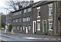
Houses on Chew Valley Road, Greenfield
The long ranges of windows suggest that those two houses might have housed home-workers, possibly in the textile trade. They date from around 1800 and are Listed Grade II.
Image: © Alan Murray-Rust
Taken: 7 Jan 2014
0.14 miles
8

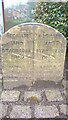
Boundary Stone, Chew Valley Road, Greenfield
Image: © Benjamin Shaw
Taken: 16 Apr 2016
0.14 miles
10
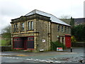
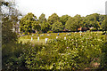
Greenfield Industrial Co-operative Society Ltd
Located next to Oak View Mills on Manchester Road in Greenfield, Saddleworth, this is the former building of the Greenfield Industrial Co-operative Society, with Alphin Pike looking down on it from behind.
Image: © Carroll Pierce
Taken: 6 Apr 2014
0.14 miles