IMAGES TAKEN NEAR TO
Chew Valley Road, OLDHAM, OL3 7AF
Introduction
This page details the photographs taken nearby to Chew Valley Road, OL3 7AF by members of the Geograph project.
The Geograph project started in 2005 with the aim of publishing, organising and preserving representative images for every square kilometre of Great Britain, Ireland and the Isle of Man.

There are currently over 7.5m images from over14,400 individuals and you can help contribute to the project by visiting https://www.geograph.org.uk
Image Map (Loading...)


Getting Data...Please wait
Leaflet Map data © OpenStreetMap
Images are licensed for reuse under creativecommons.org/licenses/by-sa/2.0
Notes
- Clicking on the map will re-center to the selected point.
- The higher the marker number, the further away the image location is from the centre of the postcode.
Image Listing (134 Images Found)
Images are licensed for reuse under creativecommons.org/licenses/by-sa/2.0
Image
Details
Distance
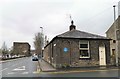
1
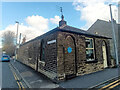
The Toll House, Saddleworth. A669
On the corner of Chew Valley and Wellington Roads. Erected by the Standedge & Oldham Turnpike Trust in the 19ᵗʰ Century. The Blue plaque says it was used from build (about 1842) until the turnpike ceased in 1885.
Grade II Listed, July 1986. Nᴼ 1067469 see https://historicengland.org.uk/listing/the-list/list-entry/1067469
Milestone Society National ID: MA.SAD01
Image: © Nigel Upton
Taken: 7 Nov 2022
0.00 miles
2
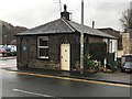
The Toll House
On Chew Valley Road, originally the Stanedge & Oldham turnpike road
Image: © Graham Hogg
Taken: 18 Mar 2019
0.00 miles
5
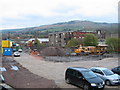
Tesco's Coming
This site is now the location of a public house called The Kingfisher and a marina which were completed in late 2008.
Also due to be built at this location during 2010 is a new Tesco store Image
Image: © Paul Anderson
Taken: 15 Nov 2006
0.02 miles
6
Nearly the end
Wellington Mill, Greenfield, in the final stages of demolition to make way for a 'TESCO' store.
Image: © Michael Fox
Taken: 9 May 2010
0.02 miles
7
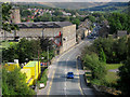
Knoll Mill Wellington Road Greenfield
This mill on the left of Wellington Road was demolished in April 2010 to make way for a Tesco store
Image
http://www.oldham-chronicle.co.uk/news-features/8/news-headlines/40003/iconic-mill-slowly-reduced-to-rubble
Image: © Paul Anderson
Taken: 15 Nov 2006
0.02 miles
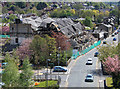
8
Wellington Road Greenfield
This is the main road through the centre of Greenfield.
The mill on the left is Image which is to be demolished
and a new Tesco store built in its place.
Image: © Paul Anderson
Taken: 15 Sep 2007
0.02 miles
9
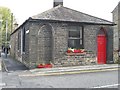
Toll cottage at Greenfield
Built about 1827 on the Chew Valley Road and ceased to take tolls in 1885
Image: © Chris Morgan
Taken: 18 Mar 2019
0.03 miles
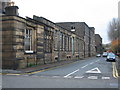
10

Camouflaged electricity sub-station
This building, on the edge of a Wimpey housing estate, is designed to look like the other houses. The fence is the give-away.
Image: © David Watson
Taken: 8 Oct 2008
0.03 miles