IMAGES TAKEN NEAR TO
Church Road, OLDHAM, OL3 6EJ
Introduction
This page details the photographs taken nearby to Church Road, OL3 6EJ by members of the Geograph project.
The Geograph project started in 2005 with the aim of publishing, organising and preserving representative images for every square kilometre of Great Britain, Ireland and the Isle of Man.

There are currently over 7.5m images from over14,400 individuals and you can help contribute to the project by visiting https://www.geograph.org.uk
Image Map (Loading...)


Getting Data...Please wait
Leaflet Map data © OpenStreetMap
Images are licensed for reuse under creativecommons.org/licenses/by-sa/2.0
Notes
- Clicking on the map will re-center to the selected point.
- The higher the marker number, the further away the image location is from the centre of the postcode.
Image Listing (7 Images Found)
Images are licensed for reuse under creativecommons.org/licenses/by-sa/2.0
Image
Details
Distance
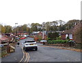
3
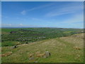
The Pots and Pans to West Yorkshire
Taken at the top of the climb up from Rye Top Lane and Knowl Top Lane, Uppermill, Saddleworth, Greater Manchester, I am looking north west across Uppermill to Delph. The moors of Rossendale, Rochdale and West Yorkshire range across the horizon beyond.
Image: © Carroll Pierce
Taken: 13 May 2018
0.06 miles
6
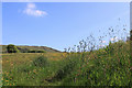
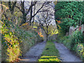
Late spring afternoon
Buttercups and sorrel in the fields near Saddleworth Fold.
Image: © Michael Fox
Taken: 2 Jun 2011
0.16 miles
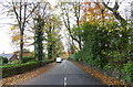
7
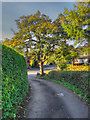
Wellmeadow Lane, Uppermill
Looking north from Church Road.
Image: © JThomas
Taken: 8 Nov 2018
0.18 miles