IMAGES TAKEN NEAR TO
Church Road, OLDHAM, OL3 6EH
Introduction
This page details the photographs taken nearby to Church Road, OL3 6EH by members of the Geograph project.
The Geograph project started in 2005 with the aim of publishing, organising and preserving representative images for every square kilometre of Great Britain, Ireland and the Isle of Man.

There are currently over 7.5m images from over14,400 individuals and you can help contribute to the project by visiting https://www.geograph.org.uk
Image Map (Loading...)


Getting Data...Please wait
Leaflet Map data © OpenStreetMap
Images are licensed for reuse under creativecommons.org/licenses/by-sa/2.0
Notes
- Clicking on the map will re-center to the selected point.
- The higher the marker number, the further away the image location is from the centre of the postcode.
Image Listing (14 Images Found)
Images are licensed for reuse under creativecommons.org/licenses/by-sa/2.0
Image
Details
Distance
4
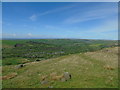
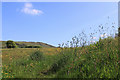
The Pots and Pans to West Yorkshire
Taken at the top of the climb up from Rye Top Lane and Knowl Top Lane, Uppermill, Saddleworth, Greater Manchester, I am looking north west across Uppermill to Delph. The moors of Rossendale, Rochdale and West Yorkshire range across the horizon beyond.
Image: © Carroll Pierce
Taken: 13 May 2018
0.11 miles
5
Late spring afternoon
Buttercups and sorrel in the fields near Saddleworth Fold.
Image: © Michael Fox
Taken: 2 Jun 2011
0.13 miles
6
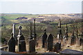
Valley View Cemetery
An appropriately named private cemetery. Harrop Edge is in the background.
Image: © Bill Boaden
Taken: 20 Apr 2013
0.16 miles
7
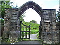
Gravestone
For the Hirst family, in St Chad's graveyard
Image: © Alexander P Kapp
Taken: 28 Jun 2007
0.17 miles
8

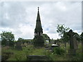
Cemetery above Tame Valley.
View from the cemetery near Saddleworth Church above Uppermill. Taken before the nearby Cross Keys pub changed hands... and their beef pie with chips and mixed veg. went too..! (The equally nearby Church Inn is OK - but who wants muzak in every available corner of every available room!)
Image: © Howard Selina
Taken: Unknown
0.17 miles
10
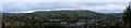
Saddleworth Moor and Uppermill
A Panorama taken from Saddlweorth Golf Club across the valley of the Tame, and the village of Uppermill, looking on toward Saddleworth Moor
This is a panorama stitched from four images of 6000x4000 pixels, giving a final size of 16108x 3508 pixels, using Microsoft's ICE. This was then reduced down to 7249 x 1579 pixels to fit Geograph's upload limits. The larger version will be available on request.
See Image for a comparison piece made in-camera
Image: © Bob Harvey
Taken: 13 Oct 2017
0.22 miles