IMAGES TAKEN NEAR TO
High Street, OLDHAM, OL3 6AW
Introduction
This page details the photographs taken nearby to High Street, OL3 6AW by members of the Geograph project.
The Geograph project started in 2005 with the aim of publishing, organising and preserving representative images for every square kilometre of Great Britain, Ireland and the Isle of Man.

There are currently over 7.5m images from over14,400 individuals and you can help contribute to the project by visiting https://www.geograph.org.uk
Image Map (Loading...)


Getting Data...Please wait
Leaflet Map data © OpenStreetMap
Images are licensed for reuse under creativecommons.org/licenses/by-sa/2.0
Notes
- Clicking on the map will re-center to the selected point.
- The higher the marker number, the further away the image location is from the centre of the postcode.
Image Listing (155 Images Found)
Images are licensed for reuse under creativecommons.org/licenses/by-sa/2.0
Image
Details
Distance
1
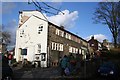
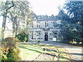
Moorland Books, Uppermill
Housed in an old weavers' cottage.
Image: © Dave Dunford
Taken: 2 Feb 2014
0.01 miles
2
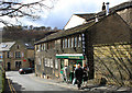
Smithy Lane, Uppermill
One of the original buildings around which the village of Uppermill grew during the nineteenth century.
Image: © Michael Fox
Taken: 4 Apr 2010
0.01 miles
3
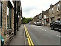
New Street
Linking Uppermill High Street with the top of Church Road, bypassing the bottom end of Church Road Image
Image: © Gerald England
Taken: 3 Jul 2013
0.03 miles
4
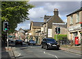
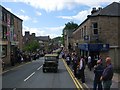
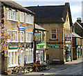
High Street, Uppermill
The main street in Uppermill, High Street originated in the 1790s as a stretch of the Oldham and Standedge turnpike road.
Image: © Michael Fox
Taken: 16 May 2010
0.03 miles
7
Army Convoy in High Street Uppermill
On the second weekend of August every year there is a wartime weekend event in Saddleworth http://www.yanksarebackinsaddleworth.co.uk/
Over the weekend there are various events throughout the area.
On the Sunday one of the biggest convoys of wartime vehicles makes its away around Saddleworth passing through
the villages of Uppermill, Delph, Standedge, Diggle, Dobcross and back to Uppermill.
If the weather is good the event brings the crowds out who line the route through all the villages.
In the photograph above the convoy makes its way along the High Street in Uppermill.
Image
Image
Image
Image
Image
Image
Image
Image: © Paul Anderson
Taken: 10 Aug 2008
0.04 miles
8
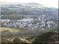
Uppermill
The village of Uppermill has seen massive building of new property over the last ten years mainly to the North of the village.
In the foreground is the main Huddersfield to Manchester railway line
Image
The monument on the top of the hill in the distance is
Image
Image: © Paul Anderson
Taken: 30 Jan 2008
0.04 miles
9
High Street, Uppermill
Buildings on the east side of High Street. Now a 'decorating centre', the building at centre right formerly housed a shop of the Uppermill Co-operative Society.At extreme right the small building was once the 'Bridge Inn'. On the left is the 'Hare and Hounds', which displays the defiant banner 'Saddleworth in the West Riding of Yorkshire' (officially Saddleworth ceased to be part of Yorkshire when it was subsumed into Oldham in 1974).
Image: © Michael Fox
Taken: 16 May 2010
0.04 miles
10
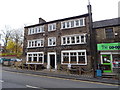
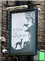
The Hare & Hounds, Uppermill
On High Street.
Image: © JThomas
Taken: 8 Nov 2018
0.04 miles