IMAGES TAKEN NEAR TO
Ammons Way, OLDHAM, OL3 5US
Introduction
This page details the photographs taken nearby to Ammons Way, OL3 5US by members of the Geograph project.
The Geograph project started in 2005 with the aim of publishing, organising and preserving representative images for every square kilometre of Great Britain, Ireland and the Isle of Man.

There are currently over 7.5m images from over14,400 individuals and you can help contribute to the project by visiting https://www.geograph.org.uk
Image Map (Loading...)


Getting Data...Please wait
Leaflet Map data © OpenStreetMap
Images are licensed for reuse under creativecommons.org/licenses/by-sa/2.0
Notes
- Clicking on the map will re-center to the selected point.
- The higher the marker number, the further away the image location is from the centre of the postcode.
Image Listing (11 Images Found)
Images are licensed for reuse under creativecommons.org/licenses/by-sa/2.0
Image
Details
Distance
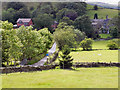
2
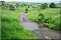
Ford at Delph
This ford is found at the end of the byway over the Hull Brook.
Image: © John Walton
Taken: 12 Jun 2016
0.06 miles
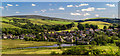
3
Valley of Hull Brook
Looking southwest towards the outskirts of Delph (visible in the distance) from the footpath linking the village with the Castleshaw reservoirs.
Image: © michael ely
Taken: 6 Jun 2007
0.07 miles
5
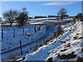
Castleshaw winter
Grange Lane - completely covered in ice - is in the foreground, Delph Greave on the horizon. Grange Lane is part of an ancient route into Saddleworth from the Rochdale area.
Image: © Michael Fox
Taken: 24 Dec 2010
0.14 miles
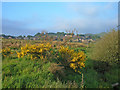
6
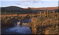
Hull Brook, Castleshaw valley
The weir feeds water into a dam that once supplied Hull Mill.
Image: © Michael Fox
Taken: Unknown
0.16 miles
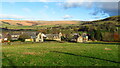
7
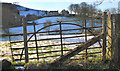
Old gate at Sandbed
The hamlet of Upper Dale is in the background.
Image: © Michael Fox
Taken: 6 Feb 2013
0.22 miles
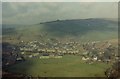
8
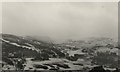
Delph Primary School 1962
Taken from Knot Hill overlooking the village, winter 1962.
Image: © William Smith
Taken: Unknown
0.23 miles
9
Delph School Mid 1960s
Taken from Knot Hill 1960s showing Delph School and Carrcote estate
Image: © William Smith
Taken: Unknown
0.23 miles
10
View Towards Upper Dale
Looking from Huddersfield Road (A62), along Dale Lane, towards Upper Dale.
Image: © David Dixon
Taken: 16 Jun 2011
0.24 miles