IMAGES TAKEN NEAR TO
Slades View Close, OLDHAM, OL3 5PE
Introduction
This page details the photographs taken nearby to Slades View Close, OL3 5PE by members of the Geograph project.
The Geograph project started in 2005 with the aim of publishing, organising and preserving representative images for every square kilometre of Great Britain, Ireland and the Isle of Man.

There are currently over 7.5m images from over14,400 individuals and you can help contribute to the project by visiting https://www.geograph.org.uk
Image Map
Images are licensed for reuse under creativecommons.org/licenses/by-sa/2.0
Notes
- Clicking on the map will re-center to the selected point.
- The higher the marker number, the further away the image location is from the centre of the postcode.
Image Listing (35 Images Found)
Images are licensed for reuse under creativecommons.org/licenses/by-sa/2.0
Image
Details
Distance
1
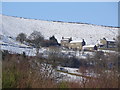
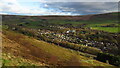
Cottages on the hillside above Diggle
Image: © Linden Milner
Taken: 31 Jan 2015
0.09 miles
2
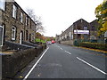
Huddersfield Road, Diggle
Looking north east.
Image: © JThomas
Taken: 8 Nov 2018
0.12 miles
3
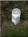
Old Milestone by the A670, Standedge Road, Diggle, Saddleworth Parish
Metal plate attached to stone post by the A670, in parish of SADDLEWORTH (OLDHAM District), Standedge Road, Diggle, 100m South of Carr Lane, just south of track onto Harrop Edge, on West side of road. Brayshaw & Booth iron casting, erected by the County Council in the 19th century.
Inscription reads:-
: HUDDERSFIELD / 12 MILES : : OLDHAM & STANDEDGE / ROAD / LORDSMERE : : MANCHESTER / 13¾ MILES / ASHTON / 7½ MILES / STALYBRIDGE / 7¼ MILES / OLDHAM / 6¾ MILES / (MOSSLEY / 4½ MILES / UPPER MILL / 1½ MILES) :
Maker:-
: BRAYSHAW & BOOTH / MAKERS / LIVERSEDGE :
Milestone Society National ID: YW_ODSD06.
Image: © C Minto
Taken: 5 Oct 2004
0.14 miles
5
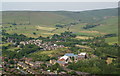
Diggle from Harrop Edge
This is where both the railway and canal, arriving from bottom right, enter their Standedge Tunnels.
Image: © Bill Boaden
Taken: 30 Jun 2010
0.15 miles
6
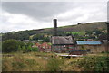
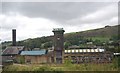
WH Shaw Mill
WH Shaw Dobcross works, for 37 years until 2006 it had been the home of Shaw’s Pallet Works, reputedly one of the largest pallet works in Europe. Known locally as ‘The Cathedral’ the main building housing the clock tower, is a Grade 2 listed building.
Image: © N Chadwick
Taken: 27 Aug 2014
0.17 miles
7
WH Shaw Mill
WH Shaw Dobcross works, for 37 years until 2006 it had been the home of Shaw’s Pallet Works, reputedly one of the largest pallet works in Europe. Known locally as ‘The Cathedral’ the main building housing the clock tower, is a Grade 2 listed building.
Image: © N Chadwick
Taken: 27 Aug 2014
0.18 miles
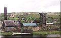
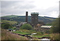
8
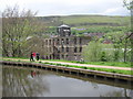
Warth Mill Diggle
Built in 1919 Warth Mill now houses a variety of different business units.
The water in the foreground is the Huddersfield Narrow Canal that runs for 20 miles between Huddersfield in West Yorkshire and Ashton under Lyne in Greater Manchester http://www.penninewaterways.co.uk/huddersfield/index.htm
Image: © Paul Anderson
Taken: 12 May 2007
0.18 miles
9
WH Shaw Mill
WH Shaw Dobcross works, for 37 years until 2006 it had been the home of Shaw’s Pallet Works, reputedly one of the largest pallet works in Europe. Known locally as ‘The Cathedral’ the main building housing the clock tower, is a Grade 2 listed building
Image: © N Chadwick
Taken: 27 Aug 2014
0.19 miles