IMAGES TAKEN NEAR TO
Dobcross New Road, OLDHAM, OL3 5NP
Introduction
This page details the photographs taken nearby to Dobcross New Road, OL3 5NP by members of the Geograph project.
The Geograph project started in 2005 with the aim of publishing, organising and preserving representative images for every square kilometre of Great Britain, Ireland and the Isle of Man.

There are currently over 7.5m images from over14,400 individuals and you can help contribute to the project by visiting https://www.geograph.org.uk
Image Map (Loading...)


Getting Data...Please wait
Leaflet Map data © OpenStreetMap
Images are licensed for reuse under creativecommons.org/licenses/by-sa/2.0
Notes
- Clicking on the map will re-center to the selected point.
- The higher the marker number, the further away the image location is from the centre of the postcode.
Image Listing (127 Images Found)
Images are licensed for reuse under creativecommons.org/licenses/by-sa/2.0
Image
Details
Distance
1
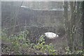
Packhorse Bridge, Uppermill
From this angle they're difficult to separate, but the road bridge in the background is the Oldham & Ripponden Trust Turnpike bridge (1864) and nearer to the camera is a medieval packhorse bridge.
Image: © Dave Dunford
Taken: 2 Feb 2014
0.04 miles
3
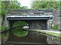
Brownhill Bridge
Bridge 73 on the Huddersfield Narrow Canal.
Image: © Christine Johnstone
Taken: 18 May 2010
0.05 miles
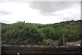
5
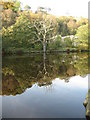
Time To Reflect
This large old dead tree stands by the side of Wool Road canal basin Dobcross
Image: © Paul Anderson
Taken: 29 Oct 2006
0.07 miles
6
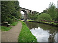
Uppermill Viaduct
The railway viaduct at Uppermill with the Huddersfield canal running underneath.
For more information about The Huddersfield Narrow Canal click on http://www.penninewaterways.co.uk/huddersfield/index.htm
Image: © Paul Anderson
Taken: 1 Oct 2006
0.08 miles
7
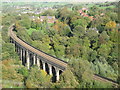
Uppermill Viaduct
Taken from above you can see the curve in the viaduct as the railway makes its way east towards Diggle and then on through the standedge tunnel
Image
Image
Image
Image
Image
Image: © Paul Anderson
Taken: 29 Oct 2006
0.08 miles
8
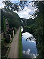
Huddersfield Narrow Canal, Uppermill
Railway Viaduct visible in distance
Image: © Philip Cornwall
Taken: 28 Aug 2021
0.08 miles
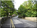
9
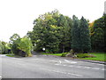
A670 Wool Road, Dobcross
At the junction with the former station approach road, which lead to Uppermill station (closed during the 1960's).
Image: © John Topping
Taken: 5 Oct 2013
0.08 miles
10
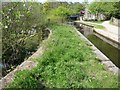
Railway Aqueduct
Railway Aqueduct is its name, not a description! It's one of the five aqueducts on the Huddesrfield Narrow canal.
Image: © Christine Johnstone
Taken: 18 May 2010
0.08 miles