IMAGES TAKEN NEAR TO
Nicker Brow, OLDHAM, OL3 5NN
Introduction
This page details the photographs taken nearby to Nicker Brow, OL3 5NN by members of the Geograph project.
The Geograph project started in 2005 with the aim of publishing, organising and preserving representative images for every square kilometre of Great Britain, Ireland and the Isle of Man.

There are currently over 7.5m images from over14,400 individuals and you can help contribute to the project by visiting https://www.geograph.org.uk
Image Map (Loading...)


Getting Data...Please wait
Leaflet Map data © OpenStreetMap
Images are licensed for reuse under creativecommons.org/licenses/by-sa/2.0
Notes
- Clicking on the map will re-center to the selected point.
- The higher the marker number, the further away the image location is from the centre of the postcode.
Image Listing (127 Images Found)
Images are licensed for reuse under creativecommons.org/licenses/by-sa/2.0
Image
Details
Distance
1
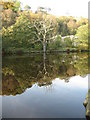
Time To Reflect
This large old dead tree stands by the side of Wool Road canal basin Dobcross
Image: © Paul Anderson
Taken: 29 Oct 2006
0.02 miles
2
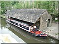
Dobcross transhipment warehouse
Before the summit tunnel at Standedge was built goods were transhipped from the Huddersfield Narrow canal at this point for transport by land over the moors to the Yorkshire section of the canal.
Image: © David Stowell
Taken: 13 Jun 2001
0.08 miles
3
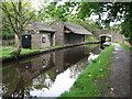
Wool Road Dobcross
Wool Road transhipment warehouse.
Goods were unloaded here to be carried by horse over the hill to Marsden before the opening of the Image in 1811.
To see photographs taken during the restoration of this area click on http://www.penninewaterways.co.uk/huddersfield/hnc52k.htm
Image: © Paul Anderson
Taken: 1 Oct 2006
0.08 miles
4
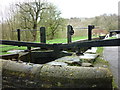
At Limekiln Lock
Limekiln Lock close up, Huddersfield Narrow Canal, Uppermill/Dobcross, Saddleworth
Image: © Carroll Pierce
Taken: 6 Apr 2014
0.08 miles
5
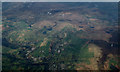
Delph and Diggle from the air
Delph is on the left, Diggle on the right. Dobcross and part of Uppermill are visible at the bottom of the photo.
Image: © Thomas Nugent
Taken: 10 Nov 2014
0.08 miles
6
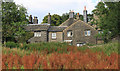
Old cottages at Docross
The location is Church Fields. In the foreground, sorrel has colonised part of a field that has been abandoned for farming.
Image: © Michael Fox
Taken: 30 Jul 2011
0.10 miles
7
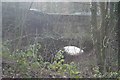
Packhorse Bridge, Uppermill
From this angle they're difficult to separate, but the road bridge in the background is the Oldham & Ripponden Trust Turnpike bridge (1864) and nearer to the camera is a medieval packhorse bridge.
Image: © Dave Dunford
Taken: 2 Feb 2014
0.10 miles
9
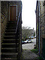
The Square, Dobcross
Stone steps leading to the back door of a large house in Dobcross. There are many attractive stone-built houses in this small Saddleworth village.
Image: © michael ely
Taken: 22 Apr 2010
0.10 miles
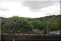
10
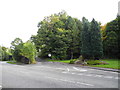
A670 Wool Road, Dobcross
At the junction with the former station approach road, which lead to Uppermill station (closed during the 1960's).
Image: © John Topping
Taken: 5 Oct 2013
0.10 miles