IMAGES TAKEN NEAR TO
Harrop Court Road, OLDHAM, OL3 5LN
Introduction
This page details the photographs taken nearby to Harrop Court Road, OL3 5LN by members of the Geograph project.
The Geograph project started in 2005 with the aim of publishing, organising and preserving representative images for every square kilometre of Great Britain, Ireland and the Isle of Man.

There are currently over 7.5m images from over14,400 individuals and you can help contribute to the project by visiting https://www.geograph.org.uk
Image Map
Images are licensed for reuse under creativecommons.org/licenses/by-sa/2.0
Notes
- Clicking on the map will re-center to the selected point.
- The higher the marker number, the further away the image location is from the centre of the postcode.
Image Listing (25 Images Found)
Images are licensed for reuse under creativecommons.org/licenses/by-sa/2.0
Image
Details
Distance
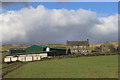
1
Harrop Dale
The view from the garden of the Diggle Hotel.
Image: © Gerald England
Taken: Unknown
0.07 miles
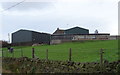
3
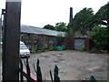
Harrop Court Mill
The yard of Harrop Court Mill. Chimneys like this are now a rarity in the Saddleworth area. I wonder how long this one will survive.
Image: © Lee Davidson
Taken: 1 Jun 2018
0.09 miles
4
Harrop Court Mill
The face of Harrop Court Mill which meets walkers on the footpath. The second door from the left (now partly overgrown) is marked as 'Reception' on the fanlight.
Image: © Lee Davidson
Taken: 1 Jun 2018
0.10 miles
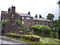
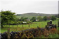
5
Ridge Farm, Diggle
This working farm is located in a long-established hamlet where two old roads over Standedge join.
Image: © Michael Fox
Taken: 4 Apr 2010
0.11 miles
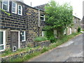
6
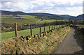
Ridge Lane, Diggle
This narrow hillside lane is likely to be on the line of an ancient trackway from Standedge to Cheshire
Image: © Michael Fox
Taken: 4 Apr 2010
0.11 miles
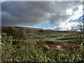
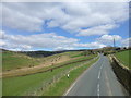
8
Fields below Standedge
On the hill behind, you can see a bus on the A62 which crosses the Pennines at this point.
Image: © Bill Boaden
Taken: 29 May 2010
0.14 miles
9
Huddersfield Road at Harrop Ridge Farm
Image: © Raymond Knapman
Taken: 11 Apr 2014
0.15 miles
10
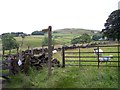
Public footpath sign at Harrop Cote Farm
Image: © Raymond Knapman
Taken: 20 Jul 2012
0.15 miles