IMAGES TAKEN NEAR TO
Dirty Lane, OLDHAM, OL3 5HS
Introduction
This page details the photographs taken nearby to Dirty Lane, OL3 5HS by members of the Geograph project.
The Geograph project started in 2005 with the aim of publishing, organising and preserving representative images for every square kilometre of Great Britain, Ireland and the Isle of Man.

There are currently over 7.5m images from over14,400 individuals and you can help contribute to the project by visiting https://www.geograph.org.uk
Image Map (Loading...)


Getting Data...Please wait
Leaflet Map data © OpenStreetMap
Images are licensed for reuse under creativecommons.org/licenses/by-sa/2.0
Notes
- Clicking on the map will re-center to the selected point.
- The higher the marker number, the further away the image location is from the centre of the postcode.
Image Listing (31 Images Found)
Images are licensed for reuse under creativecommons.org/licenses/by-sa/2.0
Image
Details
Distance
1
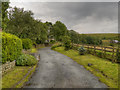
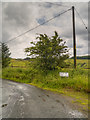
Dirty Lane
Leading to the Castleshaw reservoirs. The land on the left is the site of a Roman fort, but there doesn't appear to be much to see.
Image: © Bill Boaden
Taken: 27 Mar 2010
0.03 miles
2
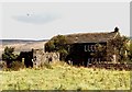
Farmhouse
Derelict farmhouse close to Roman Fort site at Castleshaw, near Delph.
Image: © Thomas E Saunders
Taken: 16 Sep 1981
0.04 miles
5
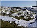
Castleshaw Roman Fortlet
Close up of the fortlet taken in winter. The snow emphasises some of the internal features. The fortlet partly overlies an earlier, larger fort.
Image: © LDBrown
Taken: 8 Feb 2012
0.07 miles
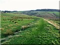
6
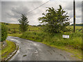
Castleshaw Roman Fort Entrance
The entrance in the inner ramparts on the south of the site
Image: © Kevin Waterhouse
Taken: 27 Nov 2020
0.08 miles
7
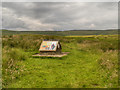
The Roman Fort at Castleshaw
One of the recently erected information boards at the site of the Roman fort on Castle Hill.
The remains of the fort are located on Castle Hill on the eastern side of, and overlooking, Castleshaw Valley at the foot of Standedge. The Roman army built two successive forts on this prominent, but bleak, hillside. It was a good position with clear views up and down the valley (see Image]).
The site is remote and exposed and lies along the Deva Victrix (Chester) to Eboracum (York) Roman road (a sort of “Roman M62”). The route crossed the Pennines at Standedge where the area dips and narrows, creating a traversable pass which would have been guarded by the Castleshaw fort.
The fort was constructed using turf and timber in approx AD 79, but fell out of use at some time during the 90s. It was replaced by a smaller fortlet, built in around AD 105 on the same site.
The site has been the subject of archaeological investigations since the 18th century, but the civilian settlement lay undiscovered until the 1990s. The fort, fortlet, and civilian settlement are all protected as a Scheduled Ancient Monument recognising its importance as a "nationally important" archaeological site.
http://en.wikipedia.org/wiki/Castleshaw_Roman_fort Castleshaw Roman Fort (Wikipedia)
Image: © David Dixon
Taken: 14 Jul 2012
0.10 miles
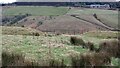
8
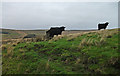
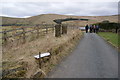
Rough grazing, Castleshaw
View from footpath around Castleshaw Upper Reservoir.
Image: © michael ely
Taken: 26 Nov 2011
0.10 miles
9
Castleshaw Roman Fort Remains
View along the inner west rampart. The Saddleworth Hotel on the A62 can just be seen top right.
Image: © Kevin Waterhouse
Taken: 9 Nov 2014
0.10 miles