IMAGES TAKEN NEAR TO
Holland Close, OLDHAM, OL3 5DP
Introduction
This page details the photographs taken nearby to Holland Close, OL3 5DP by members of the Geograph project.
The Geograph project started in 2005 with the aim of publishing, organising and preserving representative images for every square kilometre of Great Britain, Ireland and the Isle of Man.

There are currently over 7.5m images from over14,400 individuals and you can help contribute to the project by visiting https://www.geograph.org.uk
Image Map
Images are licensed for reuse under creativecommons.org/licenses/by-sa/2.0
Notes
- Clicking on the map will re-center to the selected point.
- The higher the marker number, the further away the image location is from the centre of the postcode.
Image Listing (105 Images Found)
Images are licensed for reuse under creativecommons.org/licenses/by-sa/2.0
Image
Details
Distance
1
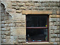
Benchmark and Flood Mark, Delph
This stone cottage is situated near the bridge in the centre of Delph on the north bank of the River Tame. A stone has been inscribed with the height of the flood of 13th July 1872 together with an Ordnance Survey benchmark symbol.
Image: © michael ely
Taken: 13 Feb 2007
0.04 miles
2
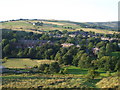
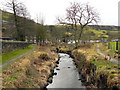
Garden Allotments in Delph
Situated next to the river Tame,close to the centre of Delph, are these garden allotments.
The row of houses in the distance are on Clifton Holmes in Image
Image: © Paul Anderson
Taken: 2 Jun 2007
0.05 miles
3
River Tame, Delph
Looking upstream from the bank, behind Gartside Street
Image: © David Dixon
Taken: 3 Feb 2011
0.07 miles
4

It's official - Delph is back in Yorkshire
This new village sign erected by Oldham Council in the corporate turquoise colour proclaims that Delph, one of the Saddleworth villages, is now back in Yorkshire. It was annexed to Greater Manchester as part of the 1974 local government boundary changes.
The sign is on Grains Road (B6197)
Image: © michael ely
Taken: 1 Jan 2010
0.07 miles
5
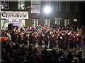
Whit Friday Brass Band Contest Delph
This is the competition ring very late in the evening in the centre of Delph where Tartan Brass are seen playing during the annual Whit Friday Brass Band Contest.
See Tartan Brass march through the village of Delph http://youtube.com/watch?v=bVW1HrRwuY8&feature=related
From the earliest recorded contest in 1884, the event has grown in popularity. This year well over a hundred brass bands participated in some twenty different contests at venues scattered around the moorland villages and towns on the western edge of the Pennines.
It is possible to look in at several contests during the evening but with over 100 bus-loads of bandsmen about and with many of the local roads closed to traffic plus the inevitable parking problems, it pays not to be over-ambitious.
Image
Image
Image
Image
Image
Image
For more information about Whit Friday Brass Band Contest click on http://www.whitfriday.brassbands.saddleworth.org/
Image: © Paul Anderson
Taken: 16 May 2008
0.07 miles
6
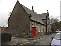
Delph Methodist Church
The methodist church on Gartside Street, Delph.
Image: © David Dixon
Taken: 3 Feb 2011
0.08 miles
7
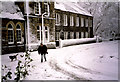
Gartside Street Delph
Taken in the winter of 1985 after a night of heavy snow and blizzard conditions
this is Gartside Street in the centre of the village of Delph.
The building is Delph Methodist Church and during the summer this is the location of the Whit Friday brass band contest as you
can see by looking at Image
Image: © Paul Anderson
Taken: Unknown
0.08 miles
8
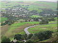
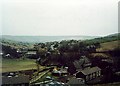
Delph Village
The village of Delph is down in the bottom of the valley.Image] This picture was taken from Hill Top Lane.
Image: © Paul Anderson
Taken: 1 Oct 2006
0.08 miles