IMAGES TAKEN NEAR TO
Pit Lane, OLDHAM, OL2 6UR
Introduction
This page details the photographs taken nearby to Pit Lane, OL2 6UR by members of the Geograph project.
The Geograph project started in 2005 with the aim of publishing, organising and preserving representative images for every square kilometre of Great Britain, Ireland and the Isle of Man.

There are currently over 7.5m images from over14,400 individuals and you can help contribute to the project by visiting https://www.geograph.org.uk
Image Map
Images are licensed for reuse under creativecommons.org/licenses/by-sa/2.0
Notes
- Clicking on the map will re-center to the selected point.
- The higher the marker number, the further away the image location is from the centre of the postcode.
Image Listing (22 Images Found)
Images are licensed for reuse under creativecommons.org/licenses/by-sa/2.0
Image
Details
Distance
1
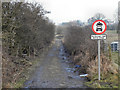
Pit Lane at Snipe Leach
Pit Lane runs from Shaw Road at Gravelhole to Rochdale Road at Burnedge. This warning sign is approximately one-third of the way along the route, at Snipe Leach.
Image: © David Dixon
Taken: 19 Jan 2011
0.03 miles
2
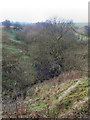
Sudden Brook
Sudden Brook, view from Pit Lane, looking towards Rochdale.
Image: © David Dixon
Taken: 19 Jan 2011
0.06 miles
3
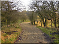
Pit Lane
Pit Lane, between Gravelhole and Burnedge.
Image: © David Dixon
Taken: 19 Jan 2011
0.07 miles
4
Capped Mineshaft
Situated on Pit Lane, part of the Rochdale Way, a muddy track between Rochdale Road, Burnedge and Castleton Road, Gravel Hole. Small scale coal mining was the industry around here in the 19th century evidenced by the name "Pit Lane" and the "Colliers Return" pub nearby.
Image: © michael ely
Taken: 4 Jun 2006
0.08 miles
5
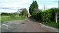
Pit Lane
Pit Lane, approximately half way between Gravelhole and Burnedge.
Image: © David Dixon
Taken: 19 Jan 2011
0.10 miles
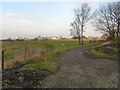
6
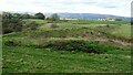
Embankment near Burnedge Pit site
This embankment built across a small side clough of Sudden Brook appears to be a dam of an old reservoir. Old OS maps do not appear to show this reservoir. There is a path along the embankment from Pit Lane to Burnedge.
Image: © Kevin Waterhouse
Taken: 28 Oct 2022
0.11 miles
7
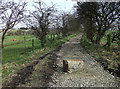
Pit Lane, Gravel Hole
This boulder has been positioned to enforce the recent traffic regulation order prohibiting motor vehicles from using the lane. It might stop cars but motorcycles could pass through quite easily.
Image: © michael ely
Taken: 15 Mar 2011
0.11 miles
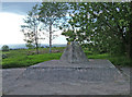
8
Pit Lane at Gravel Hole
Pit Lane from Gravel Hole to the former Burnedge Colliery was the route of a tramway and is a straight section of track
Image: © Kevin Waterhouse
Taken: 28 Oct 2022
0.14 miles
9
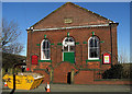
Gravel Hole Wesleyan Methodist Chapel
It is situated on Castleton Road near the junction with Pit Lane. To see the chapel as it was just over four years ago click http://www.geograph.org.uk/photo/453555 Spot the differences.
Image: © michael ely
Taken: 30 Jan 2010
0.15 miles
10
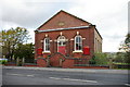
Gravel Hole Methodist Church, Royton
Image: © Alexander P Kapp
Taken: 1 Nov 2005
0.17 miles