IMAGES TAKEN NEAR TO
Sarah Butterworth Street, ROCHDALE, OL16 5EW
Introduction
This page details the photographs taken nearby to Sarah Butterworth Street, OL16 5EW by members of the Geograph project.
The Geograph project started in 2005 with the aim of publishing, organising and preserving representative images for every square kilometre of Great Britain, Ireland and the Isle of Man.

There are currently over 7.5m images from over14,400 individuals and you can help contribute to the project by visiting https://www.geograph.org.uk
Image Map (21 Images)


Getting Data...Please wait
Leaflet Map data © OpenStreetMap
Images are licensed for reuse under creativecommons.org/licenses/by-sa/2.0
Notes
- Clicking on the map will re-center to the selected point.
- The higher the marker number, the further away the image location is from the centre of the postcode.
Image Listing (21 Images Found)
Images are licensed for reuse under creativecommons.org/licenses/by-sa/2.0
Image
Details
Distance
1
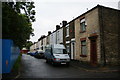
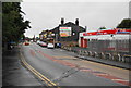
Sarah Butterworth Street
I guess Sarah Butterworth was related to James Butterworth named on the adjoining street. These are very common names locally but I think the James referred to was a local historian. This is the only surviving terraced street in the locality.
Image: © Bill Boaden
Taken: 13 Sep 2010
0.02 miles
2
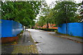
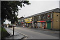
James Butterworth Street
The traditional terraces have been demolished, and many have been replaced by newer social housing, as seen in the background here.
Image: © Bill Boaden
Taken: 13 Sep 2010
0.03 miles
3
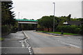
Railway bridge over Milnrow Road
This is the line from Oldham and it is being converted to take Metrolink trams.
Image: © Bill Boaden
Taken: 13 Sep 2010
0.06 miles
5
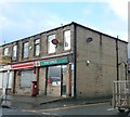
Hire shop and takeaways on Milnrow Road
Image: © Bill Boaden
Taken: 13 Sep 2010
0.10 miles
7
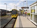
Tram Leaving Newbold
Metrolink tram 3060 leaving the Newbold tram stop/station on its journey towards Rochdale. The embankment between Kingsway and Milnrow Road has been altered so this stop is near ground level alongside the Morrisons supermarket car park.
Image: © David Dixon
Taken: 6 Oct 2013
0.13 miles
8
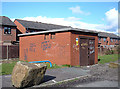
Florence Street Electricity Sub-station
Not the prettiest sub-station in Rochdale, but the walls serve a purpose.
Image: © michael ely
Taken: 5 Apr 2008
0.13 miles
9
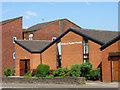
Newbold Baptist Church
Newbold Baptist Church on Milnrow Road Rochdale. In the background is Shepherd Court (Sheltered Housing).
Image: © Michael Fowler
Taken: 27 Jul 2008
0.13 miles
10
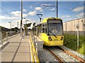
Newbold Metrolink Station
Metrolink tram 3016 leaves Newbold operating on a shortened route between Rochdale and Central Park. The embankment between Kingsway and Milnrow Road has been altered so this stop is near ground level alongside the Morrisons supermarket car park.
Image: © David Dixon
Taken: 6 Oct 2013
0.14 miles