IMAGES TAKEN NEAR TO
Stamford Street, ROCHDALE, OL16 5DS
Introduction
This page details the photographs taken nearby to Stamford Street, OL16 5DS by members of the Geograph project.
The Geograph project started in 2005 with the aim of publishing, organising and preserving representative images for every square kilometre of Great Britain, Ireland and the Isle of Man.

There are currently over 7.5m images from over14,400 individuals and you can help contribute to the project by visiting https://www.geograph.org.uk
Image Map (Loading...)


Getting Data...Please wait
Leaflet Map data © OpenStreetMap
Images are licensed for reuse under creativecommons.org/licenses/by-sa/2.0
Notes
- Clicking on the map will re-center to the selected point.
- The higher the marker number, the further away the image location is from the centre of the postcode.
Image Listing (22 Images Found)
Images are licensed for reuse under creativecommons.org/licenses/by-sa/2.0
Image
Details
Distance
1
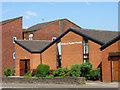
Newbold Baptist Church
Newbold Baptist Church on Milnrow Road Rochdale. In the background is Shepherd Court (Sheltered Housing).
Image: © Michael Fowler
Taken: 27 Jul 2008
0.06 miles
2
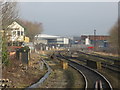
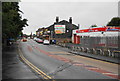
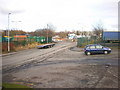
Preparation for Metrolink
At the north end of Rochdale station work is underway associated with the downgrading of the former Oldham loop railway to a Metrolink tram line. To enable the trams to access Rochdale's town centre, the tram line must cross the railway using an acutely skewed bridge which is visible in the background. Space and cost limitations mean that the new tramway will only be a single line between Kingsway and Rochdale station. The line will lead to demolition of Rochdale signalbox (seen left). The tramway bridge's specification calls for "natural steel", also known as unpainted or rust! Whether these extensive and very expensive works, plus associated tasks will be money wisely spent, compared to a simple bus shuttle into Rochdale from its station, time alone will tell.
Image: © Peter Whatley
Taken: 19 Jan 2011
0.09 miles
4
The new view north from Rochdale station
Compare with the view from the other side of the station here: http://www.geograph.org.uk/photo/2238930.
Image: © Peter Whatley
Taken: 24 Jul 2013
0.11 miles
6
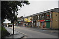
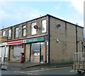
Hire shop and takeaways on Milnrow Road
Image: © Bill Boaden
Taken: 13 Sep 2010
0.11 miles
7
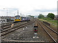
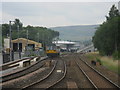
Leaving for Leeds
A local service heads north from Rochdale station.
Image: © Peter Whatley
Taken: 24 Jul 2013
0.13 miles
8
James Butterworth Street
The traditional terraces have been demolished, and many have been replaced by newer social housing, as seen in the background here.
Image: © Bill Boaden
Taken: 13 Sep 2010
0.13 miles
9
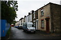
Sarah Butterworth Street
I guess Sarah Butterworth was related to James Butterworth named on the adjoining street. These are very common names locally but I think the James referred to was a local historian. This is the only surviving terraced street in the locality.
Image: © Bill Boaden
Taken: 13 Sep 2010
0.15 miles
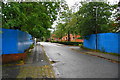
10
Chichester Street
The main service road for an industrial estate and various business parks
Image: © Alexander P Kapp
Taken: 13 Feb 2009
0.15 miles