IMAGES TAKEN NEAR TO
Slaidburn Close, ROCHDALE, OL16 4YE
Introduction
This page details the photographs taken nearby to Slaidburn Close, OL16 4YE by members of the Geograph project.
The Geograph project started in 2005 with the aim of publishing, organising and preserving representative images for every square kilometre of Great Britain, Ireland and the Isle of Man.

There are currently over 7.5m images from over14,400 individuals and you can help contribute to the project by visiting https://www.geograph.org.uk
Image Map
Images are licensed for reuse under creativecommons.org/licenses/by-sa/2.0
Notes
- Clicking on the map will re-center to the selected point.
- The higher the marker number, the further away the image location is from the centre of the postcode.
Image Listing (117 Images Found)
Images are licensed for reuse under creativecommons.org/licenses/by-sa/2.0
Image
Details
Distance
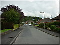
1
Lambourne Grove
This 1980s housing estate is on the site of Emmanuel Clegg's woollen mill in Milnrow.
Image: © Bryan Tenny
Taken: 17 Jan 2011
0.06 miles
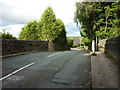
3
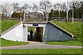
Subway short cut
This subway under Elizabethan Way allows pedestrians to get from one part of Ladyhouse Lane to the other. Ladyhouse Lane was cut when Elizabethan Way was constructed in the late 1960s early 1970s as a link road to the M62 Motorway which was constructed in the same period.
Image: © Bryan Tenny
Taken: 28 Mar 2011
0.07 miles
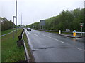
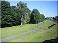
6
Ladyhouse Lane
The bridge over the railway at Ladyhouse Lane.
Image: © David Dixon
Taken: 16 Jun 2010
0.08 miles
7
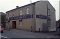
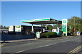
Milnrow Village Practice
Situated in a former co-operative store, Milrow village Practice is one of three Dr's surgeries in Milnrow
Image: © Bryan Tenny
Taken: Unknown
0.09 miles
9
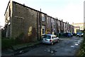
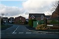
Unadopted street
This unadopted street is at the rear of a typical Victorian terrace of stone built cottages. In this case called Victoria Terrace.
Image: © Bryan Tenny
Taken: 17 Jan 2011
0.09 miles