IMAGES TAKEN NEAR TO
Shaw Road, ROCHDALE, OL16 4SH
Introduction
This page details the photographs taken nearby to Shaw Road, OL16 4SH by members of the Geograph project.
The Geograph project started in 2005 with the aim of publishing, organising and preserving representative images for every square kilometre of Great Britain, Ireland and the Isle of Man.

There are currently over 7.5m images from over14,400 individuals and you can help contribute to the project by visiting https://www.geograph.org.uk
Image Map
Images are licensed for reuse under creativecommons.org/licenses/by-sa/2.0
Notes
- Clicking on the map will re-center to the selected point.
- The higher the marker number, the further away the image location is from the centre of the postcode.
Image Listing (24 Images Found)
Images are licensed for reuse under creativecommons.org/licenses/by-sa/2.0
Image
Details
Distance
2
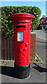
George VI postbox on Oldham Road (A671)
Postbox No. OL16 41.
See Image] for context.
Image: © JThomas
Taken: 10 Oct 2018
0.07 miles
3
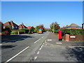
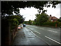
Oldham Road (A671)
Looking north west showing position of Postbox No. OL16 41.
See Image] for postbox.
Image: © JThomas
Taken: 10 Oct 2018
0.07 miles
6
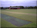
Rochdale Catholic Club Cricket Club
Rochdale Catholic Club CC play their games in the grounds of St. Cuthberts RC High School, just off Oldham Road.
They run two teams in the North Manchester Cricket League.
Image: © BatAndBall
Taken: 13 Aug 2012
0.10 miles
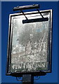
7
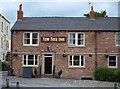
Yew Tree Inn
Pub on Oldham Road close to where the M62 crosses the road at Buersil Head.
Image: © michael ely
Taken: 23 Jun 2007
0.15 miles
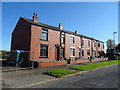
9
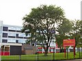
St.Cuthberts
R.C. High School opposite the Yew Tree inn below Buersil Head. Neither the school nor the motorway (not surprisingly) to the left of shot appear on the 1940s O/S map.
Image: © Roger May
Taken: 10 Oct 2005
0.16 miles