IMAGES TAKEN NEAR TO
Craiglands, ROCHDALE, OL16 4RD
Introduction
This page details the photographs taken nearby to Craiglands, OL16 4RD by members of the Geograph project.
The Geograph project started in 2005 with the aim of publishing, organising and preserving representative images for every square kilometre of Great Britain, Ireland and the Isle of Man.

There are currently over 7.5m images from over14,400 individuals and you can help contribute to the project by visiting https://www.geograph.org.uk
Image Map
Images are licensed for reuse under creativecommons.org/licenses/by-sa/2.0
Notes
- Clicking on the map will re-center to the selected point.
- The higher the marker number, the further away the image location is from the centre of the postcode.
Image Listing (21 Images Found)
Images are licensed for reuse under creativecommons.org/licenses/by-sa/2.0
Image
Details
Distance
1
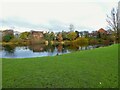
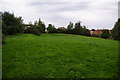
Pond in green oasis
A small green and pond exists between housing developments off Broad Lane and those off Oldham Road. From old OS maps this pond does not appear to have been connected with any former mills in the area
Image: © Kevin Waterhouse
Taken: 5 Dec 2022
0.07 miles
2
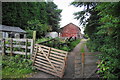
Dean Farm
This is now entirely given over to horse-riding.
Image: © Bill Boaden
Taken: 6 Sep 2010
0.07 miles
3
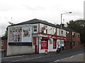
Boozed Up Convenience Store, Balderstone
Image: © John Slater
Taken: 18 Oct 2014
0.13 miles
4
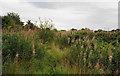
A patch of willowherbs
A common sight in this area, growing on ground that has been disturbed and then left. The seeds float off in clouds.
Image: © Bill Boaden
Taken: 6 Sep 2010
0.13 miles
5
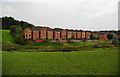
Houses on Sunhill Close
The architect has used a little bit of originality.
Image: © Bill Boaden
Taken: 6 Sep 2010
0.14 miles
7
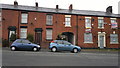
456 to 452 Oldham Road, Rochdale
From left to right are numbers 456 to 452 Oldham Road, which are terraced properties lining the A671 in the Balderstone area of Rochdale, Greater Manchester, England. Such red-brick properties are common throughout both Rochdale and Greater Manchester. Number 452 Oldham Road is boarded up in this photograph - it was formerly the Royal Hotel, a public house which has clearly closed for business.
Image: © Steven Haslington
Taken: 17 May 2012
0.15 miles
8
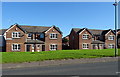
A grassy area amid the housing developments
There has been a lot of new house building in this area, but generally on small estates around the older houses. This field has probably been left as an amenity area.
Image: © Bill Boaden
Taken: 6 Sep 2010
0.16 miles

10
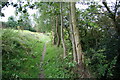
Path through the new housing estates
There are houses to right and left. This path follows the course of a ditch and I presume it predated the houses.
Image: © Bill Boaden
Taken: 6 Sep 2010
0.17 miles