IMAGES TAKEN NEAR TO
Stonefield Street, ROCHDALE, OL16 4HZ
Introduction
This page details the photographs taken nearby to Stonefield Street, OL16 4HZ by members of the Geograph project.
The Geograph project started in 2005 with the aim of publishing, organising and preserving representative images for every square kilometre of Great Britain, Ireland and the Isle of Man.

There are currently over 7.5m images from over14,400 individuals and you can help contribute to the project by visiting https://www.geograph.org.uk
Image Map
Images are licensed for reuse under creativecommons.org/licenses/by-sa/2.0
Notes
- Clicking on the map will re-center to the selected point.
- The higher the marker number, the further away the image location is from the centre of the postcode.
Image Listing (128 Images Found)
Images are licensed for reuse under creativecommons.org/licenses/by-sa/2.0
Image
Details
Distance
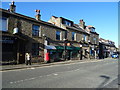
1
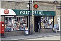
Milnrow Post Office
This is the third site of Milnrow's Post Office in a decade.
Image: © Bryan Tenny
Taken: Unknown
0.04 miles
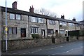
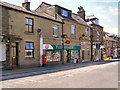
2
Former weavers' cottages
Three storey weavers' cottages currently used as shops.
Image: © Bryan Tenny
Taken: 14 Feb 2011
0.05 miles
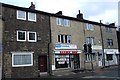
3
Two storey cottages
Possibly 'weavers' cottages judging by the blocked up portions of the first floor windows.
Image: © Bryan Tenny
Taken: 14 Feb 2011
0.05 miles
4
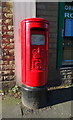
Elizabeth II postbox on Dale Street, Milnrow
Outside the Post Office.
Postbox No. OL16 202.
See Image] for context.
Image: © JThomas
Taken: 18 Oct 2018
0.05 miles
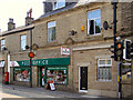
5
Post Office on Dale Street, Milnrow
Showing position of Postbox No. OL16 202.
See Image] for postbox.
Image: © JThomas
Taken: 18 Oct 2018
0.05 miles
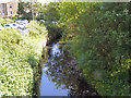
8
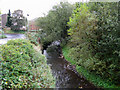
River Beal, Milnrow
Looking upstream from Station Road bridge. The Beal is rather a sad little river. Rising in the hills above Shaw and polluted almost from birth, it struggles down through New Hey and Milnrow to disgorge into the River Roch at Belfield, whence its waters join first the Irwell and then the Mersey before becoming part of the Irish Sea.
Image: © Dr Neil Clifton
Taken: 3 Oct 2009
0.05 miles
10
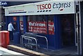
Another Tesco
This Tesco Express is in the Pennine Precinct, which was built in the early 1970's. This Tesco replaced an independent mini supermarket in 2005.
Image: © Bryan Tenny
Taken: Unknown
0.07 miles