IMAGES TAKEN NEAR TO
Bramhall Close, ROCHDALE, OL16 4BX
Introduction
This page details the photographs taken nearby to Bramhall Close, OL16 4BX by members of the Geograph project.
The Geograph project started in 2005 with the aim of publishing, organising and preserving representative images for every square kilometre of Great Britain, Ireland and the Isle of Man.

There are currently over 7.5m images from over14,400 individuals and you can help contribute to the project by visiting https://www.geograph.org.uk
Image Map
Images are licensed for reuse under creativecommons.org/licenses/by-sa/2.0
Notes
- Clicking on the map will re-center to the selected point.
- The higher the marker number, the further away the image location is from the centre of the postcode.
Image Listing (60 Images Found)
Images are licensed for reuse under creativecommons.org/licenses/by-sa/2.0
Image
Details
Distance
1
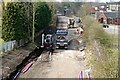
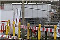
Getting there
This picture shows the continuing work on the conversion of the former 'Oldham Loop' railway line to the Manchester Metrolink tramway. Looking towards Rochdale from the Elizabethan Way road bridge it is obvious from the bridge in the distance how the track bed has been widened to accommodate cable ducting.
Image: © Bryan Tenny
Taken: 28 Mar 2011
0.03 miles
3
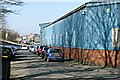
Harbour Lane North
Formerly just 'Harbour Lane', this street was severed by the construction of Elizabethan Way. Small residential streets and squares used to occupy the left hand side of the picture now filled by the new road and its embankment.
Image: © Bryan Tenny
Taken: 7 Mar 2011
0.09 miles
5
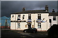
The 'Freemason's Arms' , Milnrow
Another public house recently closed and now up for sale. This is No 1, Equitable Street.
Image: © Dr Neil Clifton
Taken: 3 Oct 2009
0.10 miles
6

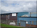
Holroyds works
An industrial building on Harbour Lane North in Milnrow.
Image: © Bryan Tenny
Taken: 16 Mar 2011
0.11 miles
7
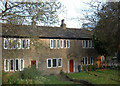
Stone cottages, Milnrow
This attractive row of cottages is at the very end of Dale St - Milnrow's main shopping street. Although rural in character they couldn't be closer to all amenities.
Image: © michael ely
Taken: 25 Nov 2005
0.11 miles
8

Vale Mill
Part of an industrial complex facing on to Clifton Street.
Image: © Bryan Tenny
Taken: 28 Feb 2011
0.12 miles
9
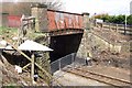
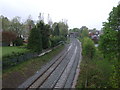
Harbour Lane North Pedestrian bridge
This bridge over the railway was closed to pedestrians from November 2010 for approx. 6 months to enable it to be replaced during the rail line's conversion to Metrolink light rail.
Image: © Bryan Tenny
Taken: 3 Apr 2010
0.13 miles
10
New footbridge at Milnrow station
This footbridge installed on February 1st 2011 replaces the old Harbour Lane North bridge over the railway. This bridge was replaced as part of the conversion of the 'Oldham Loop' railway to the Manchester Metrolink tramway.
Image: © Bryan Tenny
Taken: 1 Feb 2011
0.13 miles