IMAGES TAKEN NEAR TO
Kiln Lane, ROCHDALE, OL16 3TR
Introduction
This page details the photographs taken nearby to Kiln Lane, OL16 3TR by members of the Geograph project.
The Geograph project started in 2005 with the aim of publishing, organising and preserving representative images for every square kilometre of Great Britain, Ireland and the Isle of Man.

There are currently over 7.5m images from over14,400 individuals and you can help contribute to the project by visiting https://www.geograph.org.uk
Image Map
Images are licensed for reuse under creativecommons.org/licenses/by-sa/2.0
Notes
- Clicking on the map will re-center to the selected point.
- The higher the marker number, the further away the image location is from the centre of the postcode.
Image Listing (31 Images Found)
Images are licensed for reuse under creativecommons.org/licenses/by-sa/2.0
Image
Details
Distance
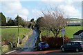
1
Bell Lane leaving Kiln Lane, Milnrow
This is a bridleway leading to Rakewood via Deep Lane.
Image: © Humphrey Bolton
Taken: 11 Apr 2019
0.05 miles
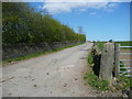
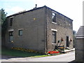
4
Into the countryside
Kiln Lane leaving the built up area of Milnrow.
Image: © Bryan Tenny
Taken: 16 Feb 2011
0.07 miles
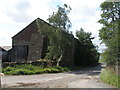
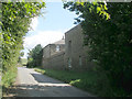
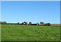
7
Flash House Farm, Milnrow
On Tunshill Lane.
Image: © JThomas
Taken: 18 Oct 2018
0.07 miles
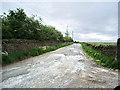
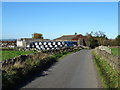
9
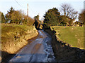
Kiln Lane
The Lane narrows to little more than a track as it approaches Flash House Farm and Ashacre.
Image: © David Dixon
Taken: 11 Feb 2010
0.10 miles