IMAGES TAKEN NEAR TO
Platt Close, ROCHDALE, OL16 3NL
Introduction
This page details the photographs taken nearby to Platt Close, OL16 3NL by members of the Geograph project.
The Geograph project started in 2005 with the aim of publishing, organising and preserving representative images for every square kilometre of Great Britain, Ireland and the Isle of Man.

There are currently over 7.5m images from over14,400 individuals and you can help contribute to the project by visiting https://www.geograph.org.uk
Image Map
Images are licensed for reuse under creativecommons.org/licenses/by-sa/2.0
Notes
- Clicking on the map will re-center to the selected point.
- The higher the marker number, the further away the image location is from the centre of the postcode.
Image Listing (97 Images Found)
Images are licensed for reuse under creativecommons.org/licenses/by-sa/2.0
Image
Details
Distance
1
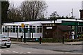
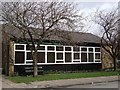
Playgroup building
A play group building built in the late 1960s.
Image: © Bryan Tenny
Taken: 16 Mar 2011
0.03 miles
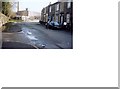
2
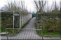
Daly's alley
A footpath diverted around the site of Daly's civil engineering compound.
Image: © Bryan Tenny
Taken: 16 Mar 2011
0.03 miles
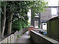
4
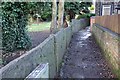
Flag Wall
A 'flag wall' made from millstone grit slabs was once a common feature of the Rochdale area. This footpath runs from near New St to Charles Lane.
Image: © Bryan Tenny
Taken: 14 Feb 2011
0.06 miles
5
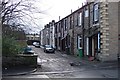
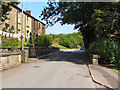
Church Terrace
Another unadopted street in Milnrow
Image: © Bryan Tenny
Taken: 14 Feb 2011
0.06 miles
6
Butterworth Hall Community Centre
Formerly built and owned by Milnrow Urban District Council around 1970 the building was taken over by volunteers as a community centre in 2004. The building is opposite the Waggon Inn in the same grid square
Image: © Bryan Tenny
Taken: Unknown
0.06 miles
7
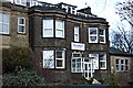
A mill owner's house
This former mill owner's house, once known as Brooklands, has been extended and converted into a care home.
Image: © Bryan Tenny
Taken: 14 Feb 2011
0.06 miles
8
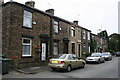
Nos. 50 to 36, Charles Lane, Milnrow
Pleasant old lane on the east side of this village - which could at one time have been referred to as a mining village. Butterworth Hall colliery was very near to this point, and several other collieries within walking distance. But all were closed long ago.
Image: © Dr Neil Clifton
Taken: 18 Sep 2009
0.06 miles
9
Charles Lane 1992
Looking along Charles Lane with Butterworth Hall Mill in the background.
Image: © Paul Hogg
Taken: Unknown
0.07 miles
10
No 1, Good Intent, Milnrow
The houses on Good Intent back directly on to those in Charles Lane, so we have examples still in 2009 of occupied and cared-for back-to-back houses. The footpath in the photograph leads into Charles Lane.
Image: © Dr Neil Clifton
Taken: 18 Sep 2009
0.07 miles