IMAGES TAKEN NEAR TO
Moorland Avenue, ROCHDALE, OL16 3DZ
Introduction
This page details the photographs taken nearby to Moorland Avenue, OL16 3DZ by members of the Geograph project.
The Geograph project started in 2005 with the aim of publishing, organising and preserving representative images for every square kilometre of Great Britain, Ireland and the Isle of Man.

There are currently over 7.5m images from over14,400 individuals and you can help contribute to the project by visiting https://www.geograph.org.uk
Image Map
Images are licensed for reuse under creativecommons.org/licenses/by-sa/2.0
Notes
- Clicking on the map will re-center to the selected point.
- The higher the marker number, the further away the image location is from the centre of the postcode.
Image Listing (106 Images Found)
Images are licensed for reuse under creativecommons.org/licenses/by-sa/2.0
Image
Details
Distance
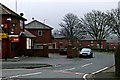
1
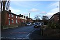
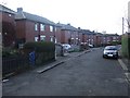
Moorland Avenue
Another part of the housing estate built between the wars on the site of the Holts farms. Viewed from Wellington Street towards the Pennine Hills
Image: © Bryan Tenny
Taken: 14 Feb 2011
0.01 miles
2
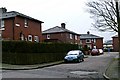
Mavis Grove
Part of the council estate built between the World Wars on the site of the Holts farms in Milnrow.
Image: © Bryan Tenny
Taken: 16 Mar 2011
0.03 miles
3
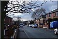
Moorland Avenue
Viewed from Wellington Street towards Harmony Street, this is another part of the estate built on the Holts farms site.
Image: © Bryan Tenny
Taken: 14 Feb 2011
0.06 miles
4
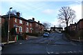
Highfield Road
Another part of the inter war housing estate built on the site of the Holts farms.
Image: © Bryan Tenny
Taken: 14 Feb 2011
0.06 miles
5
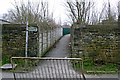
Daly's alley
A footpath diverted around the site of Daly's civil engineering compound.
Image: © Bryan Tenny
Taken: 16 Mar 2011
0.06 miles
6
Merlin Road
Part of the housing estate built on the site of the Holt's farms.
Image: © Bryan Tenny
Taken: 16 Mar 2011
0.08 miles
7
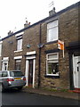
Terraced housing, Milnrow
Stone terraced housing on Cornfield Street, in Milnrow, Greater Manchester, England. Such housing stock is typical of the area.
Image: © Steven Haslington
Taken: 26 May 2011
0.09 miles
8
Playgroup building
A play group building built in the late 1960s.
Image: © Bryan Tenny
Taken: 16 Mar 2011
0.10 miles
9
Early Council Housing
Council housing built between the World Wars on the site of the Holts farms
Image: © Bryan Tenny
Taken: 30 Nov 2009
0.10 miles
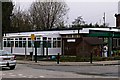
10
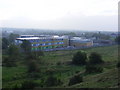
Hollingworth BEC
The new building of Hollingworth Business and Enterprise College together with the original building of Roch Valley High School.
Image: © Paul Hogg
Taken: 8 Oct 2010
0.10 miles