IMAGES TAKEN NEAR TO
Holford Walk, ROCHDALE, OL16 3BP
Introduction
This page details the photographs taken nearby to Holford Walk, OL16 3BP by members of the Geograph project.
The Geograph project started in 2005 with the aim of publishing, organising and preserving representative images for every square kilometre of Great Britain, Ireland and the Isle of Man.

There are currently over 7.5m images from over14,400 individuals and you can help contribute to the project by visiting https://www.geograph.org.uk
Image Map
Images are licensed for reuse under creativecommons.org/licenses/by-sa/2.0
Notes
- Clicking on the map will re-center to the selected point.
- The higher the marker number, the further away the image location is from the centre of the postcode.
Image Listing (65 Images Found)
Images are licensed for reuse under creativecommons.org/licenses/by-sa/2.0
Image
Details
Distance
1
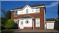
43 Juniper Drive, Firgrove
43 Juniper Drive is a detached suburban home located in the Firgrove area of Milnrow, in Greater Manchester, England.
Image: © Steven Haslington
Taken: 25 Jul 2014
0.06 miles
2
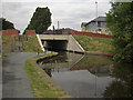
Rochdale Canal, Firgrove
Where the canal passes beneath the A640,Rochdale Road.
Image: © michael ely
Taken: 25 Jun 2010
0.08 miles
3
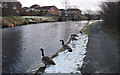
Rochdale Canal, Firgrove
Canada geese thinking of home. The housing at the top of the photo was constructed in the 1990s by Barrett.
Image: © michael ely
Taken: 31 Jan 2015
0.08 miles
4
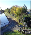
Path beside the Rochdale Canal
Looking south from the bridge on Rochdale Road.
Image: © JThomas
Taken: 18 Oct 2018
0.09 miles
5
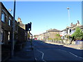
Crossing on Rochdale Road, Firgrove
Looking north west on the A640.
Image: © JThomas
Taken: 18 Oct 2018
0.09 miles
6

Kingsway Retail Park, Rochdale
Built on the corner of Kingsway and Rochdale Road on the site of a former mill.
Image: © michael ely
Taken: 7 Oct 2007
0.10 miles
7
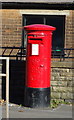
Elizabeth II postbox on Rochdale Road, Firgrove
Postbox No. OL16 8.
See Image] for context.
Image: © JThomas
Taken: 18 Oct 2018
0.10 miles
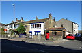
8
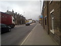
Rochdale Road, Firgrove
A view down the A640 "Rochdale" Road in Firgrove, Milnrow, Greater Manchester.
Image: © Steven Haslington
Taken: 17 Mar 2011
0.10 miles
9
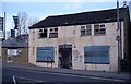
Lord Nelson Public House
A nineteenth century public house survived until around 2004/5 was demolished in 2008 and has now been replaced by a block of apartments.
Image: © Bryan Tenny
Taken: Unknown
0.10 miles
10
Houses on Rochdale Road, Firgrove
Showing position of Postbox No. OL16 8.
See Image] for postbox.
Image: © JThomas
Taken: 18 Oct 2018
0.11 miles