IMAGES TAKEN NEAR TO
Liley Street, ROCHDALE, OL16 2AS
Introduction
This page details the photographs taken nearby to Liley Street, OL16 2AS by members of the Geograph project.
The Geograph project started in 2005 with the aim of publishing, organising and preserving representative images for every square kilometre of Great Britain, Ireland and the Isle of Man.

There are currently over 7.5m images from over14,400 individuals and you can help contribute to the project by visiting https://www.geograph.org.uk
Image Map (Loading...)


Getting Data...Please wait
Leaflet Map data © OpenStreetMap
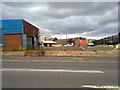
Images are licensed for reuse under creativecommons.org/licenses/by-sa/2.0
Notes
- Clicking on the map will re-center to the selected point.
- The higher the marker number, the further away the image location is from the centre of the postcode.
Image Listing (89 Images Found)
Images are licensed for reuse under creativecommons.org/licenses/by-sa/2.0
Image
Details
Distance
1
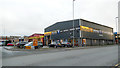
Halfords and National Tyres, Liley Street, Rochdale
Part of the town given over to motor related businesses.
Image: © Stephen Craven
Taken: 26 Nov 2018
0.02 miles
2
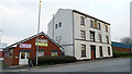
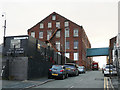
Daleprint and the former Molesworth Hotel, Rochdale
Image: © Stephen Craven
Taken: 26 Nov 2018
0.04 miles
3
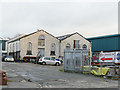
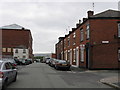
Old building on Nuttall Street, Rochdale
Nuttall Street barely exists now. Old maps show it as running between Whatmough Street and Tatham Street (the former has gone completely, the latter merely a stub). But the road name remains on this industrial building. The density of the old terraced houses can be imagined if you consider that between the photographer location on Molesworth Street, and Nuttall Street in front of this building, were two lots of houses with a back alley called Stowe Place between them. The metal gates are across what remains of Harriett Street (I wonder whether this is still technically a public highway?)
Image: © Stephen Craven
Taken: 26 Nov 2018
0.05 miles
4
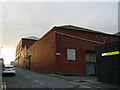
Livsey Street, Rochdale
This end of the street is in the industrial area on the edge of town. The other end is at Drake Street in the town centre.
Image: © Stephen Craven
Taken: 26 Nov 2018
0.05 miles
6
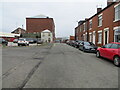
Hill Street, Rochdale
Part of the town still given over to industry.
Image: © Stephen Craven
Taken: 26 Nov 2018
0.08 miles
7
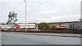
Retail park, Molesworth Street, Rochdale
TK-Maxx and Home Bargains are the principal retailers.
Image: © Stephen Craven
Taken: 26 Nov 2018
0.08 miles
8
Livsey Street, Rochdale
Looking north-eastward.
Image: © Peter Wood
Taken: 7 Feb 2023
0.08 miles
9
Molesworth Street, Rochdale
In this rather grim photograph, across from Molesworth Street in Rochdale, is a piece of industrial wasteland cum car park. One of the more uglier parts of Rochdale, but sadly common in many of the post-industrial towns of Greater Manchester and North West England.
Image: © Steven Haslington
Taken: 6 Jun 2011
0.09 miles
10
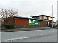
Springhill Emporium, Molesworth Street, Rochdale
Despite the fancy title, this is a charity shop for the Springhill Hospice.
Image: © Stephen Craven
Taken: 26 Nov 2018
0.10 miles