IMAGES TAKEN NEAR TO
Packer Street, ROCHDALE, OL16 1NJ
Introduction
This page details the photographs taken nearby to Packer Street, OL16 1NJ by members of the Geograph project.
The Geograph project started in 2005 with the aim of publishing, organising and preserving representative images for every square kilometre of Great Britain, Ireland and the Isle of Man.

There are currently over 7.5m images from over14,400 individuals and you can help contribute to the project by visiting https://www.geograph.org.uk
Image Map (Loading...)


Getting Data...Please wait
Leaflet Map data © OpenStreetMap
Images are licensed for reuse under creativecommons.org/licenses/by-sa/2.0
Notes
- Clicking on the map will re-center to the selected point.
- The higher the marker number, the further away the image location is from the centre of the postcode.
Image Listing (532 Images Found)
Images are licensed for reuse under creativecommons.org/licenses/by-sa/2.0
Image
Details
Distance
1
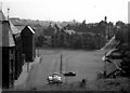
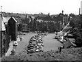
Town Hall Square, Rochdale, Lancashire
The very small number of motor cars seen in this 1968 view is explained by the fact that this was taken quite early on a Sunday morning. Note the trees now growing in front of the 'Flying Horse'. The steep road leading up to the right is Nelson Street, and the large building on the left of this street is the Technical School. The small building right foreground with Tudor-effect gable is the town mortuary.
Image: © Dr Neil Clifton
Taken: 28 Jul 1968
0.00 miles
2
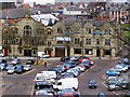
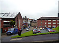
Flying Horse Hotel
Looking across the town hall car park from Broadfield Park
Image: © David Dixon
Taken: 10 Feb 2010
0.01 miles
3
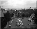
Town Hall Square, Rochdale, Lancashire
In this 1970 view it is obvious that by now car-parking space was becoming difficult to find.
Image: © Dr Neil Clifton
Taken: 17 Aug 1970
0.01 miles
4
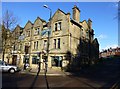
The Flying Horse Hotel
This is on Town Hall Square and is faced by a large area of pay and display parking.
Image: © Bill Boaden
Taken: 31 Dec 2010
0.01 miles
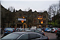
6
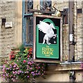
Sign for the Flying Horse Hotel
According to the sign, the Flying Horse Image was established in 1691.
Image: © Gerald England
Taken: 22 Sep 2016
0.01 miles
7
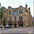
The Flying Horse
On the corner of Packer Street and Nelson Street. According to their Facebook page https://www.facebook.com/pg/FlyerRochdale/about/
"First opened in 1691 on Rochdale's most dangerous street, rebuilt in 1923 and reopened in 1926 the Flying Horse Hotel is the oldest free house in Rochdale and was once the post office and court house.
By 1819 amenities included a dwelling house, brew house, garden and cottage, all leased to James Whitehead, innkeeper, of Packer Street. In 1823 the committee appointed to gain a Police Act for the town met there, and in 1854 Rochdale's first Revision Court was held on the premises. ...
Demolition of the old Flying Horse Hotel was recorded in the Rochdale Observer of 26th June, 1923 ... The present building, re-named the Flying Horse after a spell as "The Sports," opened in the summer of 1926 with landlord James Berry at the pumps. It was three storeys high and boasted a smoke room, commercial room, parlour and bar on the ground floor. On the first floor the dining room fronted onto the Town Hall Square and six second floor bedrooms offered all mod cons to its patrons, including electric lights and heating.
It is now owned by business partners Ben Boothman and Craig Richardson who bought the business from Sam & Per Bonde back in April 2011. ... "The Flyer" is the proud sponsor of the Rochdale "Feel Good festival", ... The pub recently won Rochdale. Oldham and Bury CAMRA pub of the year."
Image
Image: © Gerald England
Taken: 22 Sep 2016
0.01 miles
8
Town Hall Square, Rochdale, Lancashire
Seen here in 1966 two years after my previous photograph. The Town Hall square is now full of motor cars. The Ribble bus service to Blackburn, seen opposite, now needs double-deckers.
Image: © Dr Neil Clifton
Taken: 16 Aug 1966
0.02 miles
9
Rochdale: King Street
Looking north from its junction with Nelson Street. The ground on the right was formerly occupied by the large building which housed the Technical School, the Art School, the Municipal High School for Boys, and the Central School for Girls.
Image: © Dr Neil Clifton
Taken: 21 Sep 2013
0.02 miles
10
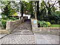
Church Steps
Leading from the Town Hall Square to St Chad's. A blue plaque Image provides some information.
Image: © Gerald England
Taken: 22 Sep 2016
0.02 miles