IMAGES TAKEN NEAR TO
Stansfield Hall, LITTLEBOROUGH, OL15 9RH
Introduction
This page details the photographs taken nearby to Stansfield Hall, OL15 9RH by members of the Geograph project.
The Geograph project started in 2005 with the aim of publishing, organising and preserving representative images for every square kilometre of Great Britain, Ireland and the Isle of Man.

There are currently over 7.5m images from over14,400 individuals and you can help contribute to the project by visiting https://www.geograph.org.uk
Image Map
Images are licensed for reuse under creativecommons.org/licenses/by-sa/2.0
Notes
- Clicking on the map will re-center to the selected point.
- The higher the marker number, the further away the image location is from the centre of the postcode.
Image Listing (90 Images Found)
Images are licensed for reuse under creativecommons.org/licenses/by-sa/2.0
Image
Details
Distance
1
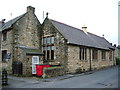
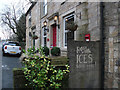
Former Stansfield Hall Infant School.
Has now been converted into Stansfield Hall Nursing Home
Image: © Alexander P Kapp
Taken: 30 May 2007
0.06 miles
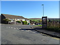
2
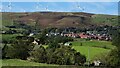
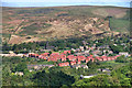
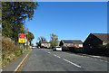
Barnes Meadow Estate
The red brick houses of the estate are prominent in this view from a path to New Barn on the A58 Halifax Road. Crook Moor wind farm is on the skyline
Image: © Kevin Waterhouse
Taken: 27 Sep 2020
0.07 miles
7
Road closure on Calderbrook Road
Diversion available via the A6033.
Image: © JThomas
Taken: 18 Oct 2018
0.12 miles
8
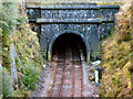
Entrance to Summit Tunnel.
Construction started in February 1838 and was completed in September 1840, there were 41 fatal accidents during construction and at that time with a length of 2,869 yards it was the longest in the world.
Image: © Jeff Mills
Taken: 10 Oct 2004
0.12 miles
10
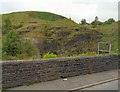
Summit Rockface
At the Southern end of the Summit tunnel, wire mesh is attached to the rockface to mitigate the effects of landslides falling on the railway.
Image: © Gerald England
Taken: 10 Jun 2010
0.13 miles