IMAGES TAKEN NEAR TO
Barnes Meadows, LITTLEBOROUGH, OL15 9PR
Introduction
This page details the photographs taken nearby to Barnes Meadows, OL15 9PR by members of the Geograph project.
The Geograph project started in 2005 with the aim of publishing, organising and preserving representative images for every square kilometre of Great Britain, Ireland and the Isle of Man.

There are currently over 7.5m images from over14,400 individuals and you can help contribute to the project by visiting https://www.geograph.org.uk
Image Map
Images are licensed for reuse under creativecommons.org/licenses/by-sa/2.0
Notes
- Clicking on the map will re-center to the selected point.
- The higher the marker number, the further away the image location is from the centre of the postcode.
Image Listing (115 Images Found)
Images are licensed for reuse under creativecommons.org/licenses/by-sa/2.0
Image
Details
Distance
1
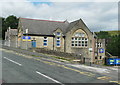
Church of England primary School. Calderbrook. Littleborough
This first appears on the 1910 edition of the 1:2500 map.
Image: © Humphrey Bolton
Taken: 24 Jul 2017
0.01 miles
2
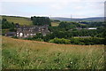
Hillside above Stansfield Hall Primary School
This spot has views across the Roch valley to Sladen Fold.
Image: © Bill Boaden
Taken: 20 Jul 2013
0.02 miles
3
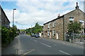
Todmorden Road (A6033) Summit, Littleborough
Image: © Humphrey Bolton
Taken: 24 Jul 2017
0.03 miles
4
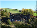
Rock Nook Mill, Littleborough
Former Fothergill & Harvey Textile Mill.
View from Barnes Meadows.
Image: © JThomas
Taken: 18 Oct 2018
0.04 miles
5
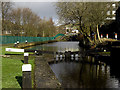
Thickone Lock no 43 Rochdale Canal
Looking north towards Summit. There are numerous canal-side mills still in operation on this stretch of the Rochdale Canal.
Image: © michael ely
Taken: 28 Jan 2010
0.07 miles
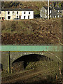
6
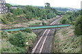
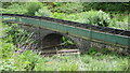
River Roch aqueduct over the Lancashire and Yorkshire railway
When the Manchester and Leeds Railway was constructed, the problem of how to cross the Pennines had to be considered carefully, as steam engines then had very little power to climb severe gradients. So Summit Tunnel, which at the time was the longest railway tunnel in the world, was constructed, but in order to run the railway from the Littleborough end into the tunnel, the infant River Roch was diverted to run in this iron trough, supported by a brick arch, to take it across the railway. The aqueduct still survives and I am not aware of a similar one anywhere else in Britain, or even abroad.
Image: © Dr Neil Clifton
Taken: 23 Aug 2006
0.07 miles
7
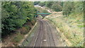
Railway Approach to River Roch Aqueduct
Beyond the aqueduct is the tunnel under Todmorden Road and then Summit Tunnel
Image: © Kevin Waterhouse
Taken: 20 Sep 2016
0.07 miles
8
Aqueduct across the railway near Summit
View from the Rochdale Canal near Greenvale Top Lock no 42. The houses are on the A6033, Todmorden Road, near Summit.
Image: © michael ely
Taken: 28 Jan 2010
0.08 miles
9
River Roch Aqueduct
Over the Manchester-Leeds Railway viewed from Todmorden Road at Rock Nook
Image: © Kevin Waterhouse
Taken: 5 Jun 2020
0.08 miles
10
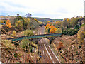
Railway, Aqueduct and Bridge
Looking south from the bridge near Rock Nook, the green structure in the foreground is Image], the bridge in the distance carries a path from Reddyshore Lane over the railway, to the Rochdale Canal. (The bridge is in Image).
Image: © David Dixon
Taken: 29 Oct 2010
0.08 miles