IMAGES TAKEN NEAR TO
Chestnut Way, LITTLEBOROUGH, OL15 8RW
Introduction
This page details the photographs taken nearby to Chestnut Way, OL15 8RW by members of the Geograph project.
The Geograph project started in 2005 with the aim of publishing, organising and preserving representative images for every square kilometre of Great Britain, Ireland and the Isle of Man.

There are currently over 7.5m images from over14,400 individuals and you can help contribute to the project by visiting https://www.geograph.org.uk
Image Map
Images are licensed for reuse under creativecommons.org/licenses/by-sa/2.0
Notes
- Clicking on the map will re-center to the selected point.
- The higher the marker number, the further away the image location is from the centre of the postcode.
Image Listing (18 Images Found)
Images are licensed for reuse under creativecommons.org/licenses/by-sa/2.0
Image
Details
Distance
1
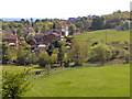
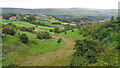
View Towards Middle Starring From Shore
Image: © David Dixon
Taken: 18 May 2010
0.14 miles
2
Capped Mine Shaft
Old shaft on Starring Hill, not marked as a named colliery on OS maps
Image: © Kevin Waterhouse
Taken: 7 Oct 2020
0.15 miles
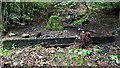
3
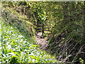
Old workings on Starring Hill
There are various excavations associated with the pipe works for fire clay and coal
Image: © Kevin Waterhouse
Taken: 14 Feb 2019
0.18 miles
4
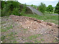
Archaeology at Starring Pipe Works Site
A trench dug across the entrance to the site
Image: © Kevin Waterhouse
Taken: 17 May 2016
0.19 miles
5
Middlewood Colliery Site
In the valley bottom between Pedler Brow and Starring Hill, only scant spoil heaps remain
Image: © Kevin Waterhouse
Taken: 6 Sep 2016
0.20 miles
6
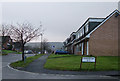
Private Housing, Littleborough.
An estate of semi-detached dormer bungalows built in the late 1960s/early 1970s on farmland near Littleborough.
Image: © michael ely
Taken: 10 Dec 2005
0.21 miles
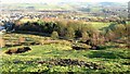
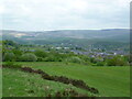
7
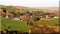
Shore from Starring Hill
The fields in the middle right surrounded by copper birch edges are known locally as the 'rhubarb fields' since this and other produce was grown here for the local preserve and pickle factory
Image: © Kevin Waterhouse
Taken: 14 Feb 2019
0.21 miles
9
Corner of Dearnley Playing Fields
With Blackstone Edge on the skyline
Image: © Kevin Waterhouse
Taken: 17 May 2016
0.22 miles
10
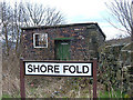
Shore Fold, Shore
A derelict storage shed opposite the King William IV pub. Only the facade and one wall remain.
Image: © michael ely
Taken: 16 Mar 2008
0.23 miles