IMAGES TAKEN NEAR TO
St. Andrews Close, LITTLEBOROUGH, OL15 8PG
Introduction
This page details the photographs taken nearby to St. Andrews Close, OL15 8PG by members of the Geograph project.
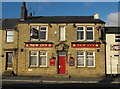
The Geograph project started in 2005 with the aim of publishing, organising and preserving representative images for every square kilometre of Great Britain, Ireland and the Isle of Man.

There are currently over 7.5m images from over14,400 individuals and you can help contribute to the project by visiting https://www.geograph.org.uk
Image Map
Images are licensed for reuse under creativecommons.org/licenses/by-sa/2.0
Notes
- Clicking on the map will re-center to the selected point.
- The higher the marker number, the further away the image location is from the centre of the postcode.
Image Listing (40 Images Found)
Images are licensed for reuse under creativecommons.org/licenses/by-sa/2.0
Image
Details
Distance
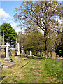
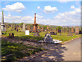
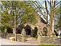
2
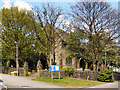
St Andrew's Parish Church
The Parish Church of St Andrew, Dearnley and Smithy Bridge. On Arm Road, Dearnley
Image: © David Dixon
Taken: 18 May 2010
0.04 miles
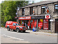
4
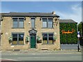
Pandora, Dearnley
Pandora Indian Restaurant, 122 New Road (A58), Littleborough OL15 8NL, formerly the Green Door, formerly the New Inn.
New Inn geograph: https://www.geograph.org.uk/photo/1855108
Green Door geograph: https://www.geograph.org.uk/photo/4252148
The Green Door closed during the 2021 coronavirus pandemic.
In 'A History of Littleborough Pubs' (Tempus Publishing & Littleborough Historical & Archaeological Society) James Thwaite is recorded as the licensee 1933-1937.
Image: © Peter Thwaite
Taken: 24 May 2023
0.05 miles
5
Green Door, Dearnley
The Green Door Restaurant, 122 New Road (the A58), on the corner with Arm Road, was formerly the New Inn pub:
geograph: http://www.geograph.org.uk/photo/1855108
restaurant's website: http://www.greendoorrestaurant.co.uk/
The Green Door closed during the 2021 corona virus pandemic and re-opened as the Pandora. geograph: https://www.geograph.org.uk/photo/7499105
In 'A History of Littleborough Pubs' (Tempus Publishing & Littleborough Historical & Archaeological Society) James Thwaite is recorded as the licensee 1933-1937.
Image: © Peter Thwaite
Taken: 17 Oct 2014
0.05 miles
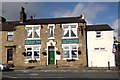
6
New Inn, Dearnley
The New Inn, 122 New Road (the A58), on the corner with Arm Road, is now permanently closed and awaits conversion to flats.
Re-opened as the Green Door restaurant: http://www.geograph.org.uk/photo/4252148
And subsequently re-opened as the Pandora: https://www.geograph.org.uk/photo/7499105
In 'A History of Littleborough Pubs' (Tempus Publishing & Littleborough Historical & Archaeological Society) James Thwaite is recorded as the licensee 1933-1937.
Image: © Peter Thwaite
Taken: 25 Dec 2008
0.05 miles
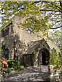
7
St Andrew's School, Dearnley
The school was built in the 1970s to replace the similarly named Church of England school that was situated on School Street on the other (east) side of Saint Andrew's church. The school day has ended and the shutters are drawn down on the windows and doors.
Saint Andrew's CE Primary School website: http://www.clc2.uniservity.com/Grouphomepage.asp?GroupId=392834
Saint Andrew's church website: http://www.standrewsdearnley.co.uk/
Image: © Peter Thwaite
Taken: 22 Apr 2010
0.07 miles