IMAGES TAKEN NEAR TO
Eastwood Road, TODMORDEN, OL14 8RY
Introduction
This page details the photographs taken nearby to Eastwood Road, OL14 8RY by members of the Geograph project.
The Geograph project started in 2005 with the aim of publishing, organising and preserving representative images for every square kilometre of Great Britain, Ireland and the Isle of Man.

There are currently over 7.5m images from over14,400 individuals and you can help contribute to the project by visiting https://www.geograph.org.uk
Image Map
Images are licensed for reuse under creativecommons.org/licenses/by-sa/2.0
Notes
- Clicking on the map will re-center to the selected point.
- The higher the marker number, the further away the image location is from the centre of the postcode.
Image Listing (17 Images Found)
Images are licensed for reuse under creativecommons.org/licenses/by-sa/2.0
Image
Details
Distance
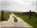
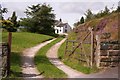
1
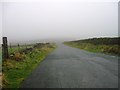
Footpath and cattle grid
Looking N from Eastwood Road at SD 945 265.
Image: © Mark Anderson
Taken: 23 Aug 2005
0.04 miles
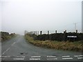
4
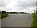
Road junction
Of Broad Lane with Eastwood Road
Image: © Alexander P Kapp
Taken: 5 Jun 2009
0.10 miles
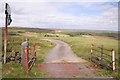
7
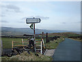
Keelam Heights
At the junction of Eastwood Road and Broad Lane looking east. A shot of the cattle grid looking north can be seen here Image
Image: © michael ely
Taken: 14 Mar 2008
0.12 miles
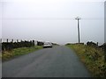
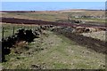
8
Hall Stones Green Farm
Looking NW from Broad Lane at SD 945 262.
Image: © Mark Anderson
Taken: 23 Aug 2005
0.15 miles
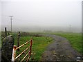
9
Public Footpath descending towards Daisy Bank Clough
Image: © Chris Heaton
Taken: 5 Apr 2018
0.15 miles