IMAGES TAKEN NEAR TO
East Lee Lane, TODMORDEN, OL14 8RW
Introduction
This page details the photographs taken nearby to East Lee Lane, OL14 8RW by members of the Geograph project.
The Geograph project started in 2005 with the aim of publishing, organising and preserving representative images for every square kilometre of Great Britain, Ireland and the Isle of Man.

There are currently over 7.5m images from over14,400 individuals and you can help contribute to the project by visiting https://www.geograph.org.uk
Image Map
Images are licensed for reuse under creativecommons.org/licenses/by-sa/2.0
Notes
- Clicking on the map will re-center to the selected point.
- The higher the marker number, the further away the image location is from the centre of the postcode.
Image Listing (16 Images Found)
Images are licensed for reuse under creativecommons.org/licenses/by-sa/2.0
Image
Details
Distance
1
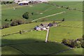
Pex Tenements
View of Pex Tenements Farm seen from Stoodley Pike Monument.
Image: © Peter McDermott
Taken: 14 May 2016
0.13 miles
2
Looking across Great House Clough towards Pex Tenements Farm
Image: © Chris Heaton
Taken: 6 Jan 2023
0.13 miles
3
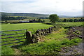
Path to Pex Tenement Farm
Gentle farmland on a shelf above Calderdale.
Image: © Bill Boaden
Taken: 29 Jun 2013
0.16 miles
4
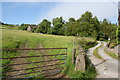
Track to Chapel House Farm
The sign is to deter satnav users from coming up here as it is a dead end.
Image: © Bill Boaden
Taken: 29 Jun 2013
0.18 miles
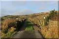
5
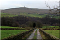
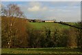
On Eastwood Lane
Descending into the depths of the Calder Valley from Upper Eastwood.
The monument standing on Stoodley Pike can be seen directly ahead.
Image: © Chris Heaton
Taken: 6 Jan 2023
0.20 miles
6
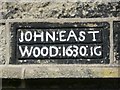
Date stone on cottages behind Eastwood Old Hall, Stansfield, Todmorden
Quite an old date: 1630. The name John Eastwood seems to come from an ancester who made a farm in the East Wood of Stansfield. He would have been a clothier as well as a farmer. Perhaps John Eastwood lived in this cottage before building the Old Hall.
Image: © Humphrey Bolton
Taken: 17 Jun 2010
0.20 miles
7
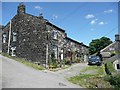
Cottages at Higher Eastwood, Stansfield, Todmorden
A row of four early 17C cottages (one is dated 1630 - see Image) with a 19C house added to the near end.
Image: © Humphrey Bolton
Taken: 17 Jun 2010
0.20 miles
8
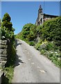
Eastwood Lane, Higher Eastwood, Stansfield
Very steep as it climbs up from the hamlet. According to the Charlestown History Group website http://charlestownhistory.org.uk/eastwood/highereastwood.html there was a tollhouse in the hamlet at one time. The tolls were levied on cartloads of stone travelling from quarries to the canal or railway in the valley.
Image: © Humphrey Bolton
Taken: 17 Jun 2010
0.20 miles
9
New Road
Access lane heading towards Great House Farm from Upper Eastwood
Image: © Chris Heaton
Taken: 6 Jan 2023
0.21 miles
10
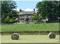
Eastwood Old Hall, Stansfield, Todmorden
So named on the OS map, but now called Old Hall Farm according to the Charlestown History Group website http://charlestownhistory.org.uk/eastwood/highereastwood.html . It is assumed to have been built in the 18C on the evidence of a date '1767' on the barn. However it looks like a 17C farmer / clothier's house, gentrified by the addition of a pedimented doorway. The long window on the first floor would have been to light a loom shop, with access from the higher ground at the rear. The Eastwood family are recorded from the 13C, no doubt taking their name from the East Wood of Stansfield township.
Image: © Humphrey Bolton
Taken: 17 Jun 2010
0.23 miles