IMAGES TAKEN NEAR TO
Pudsey Road, TODMORDEN, OL14 8NR
Introduction
This page details the photographs taken nearby to Pudsey Road, OL14 8NR by members of the Geograph project.
The Geograph project started in 2005 with the aim of publishing, organising and preserving representative images for every square kilometre of Great Britain, Ireland and the Isle of Man.

There are currently over 7.5m images from over14,400 individuals and you can help contribute to the project by visiting https://www.geograph.org.uk
Image Map
Images are licensed for reuse under creativecommons.org/licenses/by-sa/2.0
Notes
- Clicking on the map will re-center to the selected point.
- The higher the marker number, the further away the image location is from the centre of the postcode.
Image Listing (68 Images Found)
Images are licensed for reuse under creativecommons.org/licenses/by-sa/2.0
Image
Details
Distance
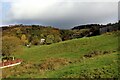
3

View of Pudsey, Todmorden
This was taken from a little rocky knoll at the top of the steep footpath up through Dawk Hole Wood.
Image: © Humphrey Bolton
Taken: 21 Feb 2019
0.08 miles

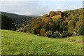
8

Todmorden FP66 in Dawk Hole Wood, Pudsey
Image: © Humphrey Bolton
Taken: 21 Feb 2019
0.14 miles
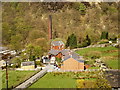
9
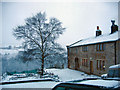
Mount Pleasant Farm
View towards Brown Birks.
Image: © Mount Pleasant
Taken: 25 Dec 2004
0.14 miles
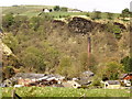
10
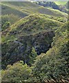
Safety Fencing at Dawk Hole
View across Dawk Hole to path climbing above virtual sheer face of Dawk Hole with old wooden fence for safety
Image: © Kevin Waterhouse
Taken: 29 Sep 2020
0.14 miles