IMAGES TAKEN NEAR TO
Rosebery Street, TODMORDEN, OL14 8LS
Introduction
This page details the photographs taken nearby to Rosebery Street, OL14 8LS by members of the Geograph project.
The Geograph project started in 2005 with the aim of publishing, organising and preserving representative images for every square kilometre of Great Britain, Ireland and the Isle of Man.

There are currently over 7.5m images from over14,400 individuals and you can help contribute to the project by visiting https://www.geograph.org.uk
Image Map
Images are licensed for reuse under creativecommons.org/licenses/by-sa/2.0
Notes
- Clicking on the map will re-center to the selected point.
- The higher the marker number, the further away the image location is from the centre of the postcode.
Image Listing (124 Images Found)
Images are licensed for reuse under creativecommons.org/licenses/by-sa/2.0
Image
Details
Distance

2
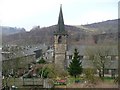
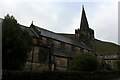
Church of St Michael and All Angels, Vale, Cornholme, Todmorden
The ecclesiastical parish was created in 1903, so the church might have been built around that time. Cornholme was also a civil parish from 1894 until 1897, although it was part of Todmorden Urban District (Municipal Borough from 1896). It was the part of Cliviger that was transferred from Lancashire to Yorkshire in 1889.
Image: © Humphrey Bolton
Taken: 3 Mar 2011
0.00 miles
3
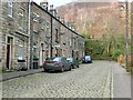
Garfield Street, Vale, Todmorden
The street ends at a cliff, above which is the railway.
Image: © Humphrey Bolton
Taken: 3 Mar 2011
0.00 miles
4
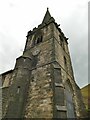
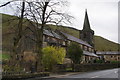
Spire of St Michael & All Angels, Cornholme
The church was built in 1902, architect Hodgson Fowler of Durham, and according to Historic England was built for Mrs Master-Whitaker of the Holme, Cliviger (grade II list entry 1133755). It formerly had its own parish but is now a chapel of ease to the parish of Todmorden. Alexander Kapp has supplied several images of the church, inside and out https://www.geograph.org.uk/stuff/list.php?title=St+Michael+and+All+Angels%2C+The+Parish+Church+of+&gridref=SD9126
The historic county boundary runs along the south side of the main road through the village - where the photographer is standing - so the church and vicarage were just on the Lancashire side, though the parish belonged to the Wakefield diocese rather than Blackburn or Manchester.
Image: © Stephen Craven
Taken: 2 May 2022
0.01 miles
5
Cornholme - house at Rosebery Street
At its junction with Burnley Road. Back in the 1800's this building was the Todmorden Liberal Club. The façade has changed a little over the years, the roofline has been altered, and it has now been converted into 2 separate dwellings (one of which was for sale in 2016). See also http://www.pennineheritage.org.uk/document/9131.
Image: © Dave Bevis
Taken: 26 Jul 2014
0.02 miles
6
St. Michael and All Angels Church, Cornholme
Early 20th Century Church that serves the parish of Cornholme - and a Grade II Listed Building.
Image: © Chris Heaton
Taken: 25 Oct 2022
0.02 miles
7
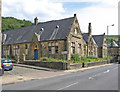
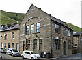
Cornholme - former Vale Board School - west end
For other views of this semi-derelict school, please see Image, Image, Image and Betty Longbottom's Image
Image: © Dave Bevis
Taken: 26 Jul 2014
0.02 miles
8

St Michael's Church - Burnley Road, Cornholme
Image: © Betty Longbottom
Taken: 29 Aug 2007
0.02 miles
9
St Michael and All Angels Church, Cornholme
Image: © Bill Boaden
Taken: 24 Dec 2011
0.03 miles
10
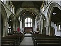
Interior of St Michael & All Angels, Cornholme
The church was built in 1902, architect Hodgson Fowler of Durham, and according to Historic England was built for Mrs Master-Whitaker of the Holme, Cliviger (grade II list entry 1133755). See Image for the spire.
Image: © Stephen Craven
Taken: 2 May 2022
0.03 miles