IMAGES TAKEN NEAR TO
Thomas Street, TODMORDEN, OL14 8JP
Introduction
This page details the photographs taken nearby to Thomas Street, OL14 8JP by members of the Geograph project.
The Geograph project started in 2005 with the aim of publishing, organising and preserving representative images for every square kilometre of Great Britain, Ireland and the Isle of Man.

There are currently over 7.5m images from over14,400 individuals and you can help contribute to the project by visiting https://www.geograph.org.uk
Image Map
Images are licensed for reuse under creativecommons.org/licenses/by-sa/2.0
Notes
- Clicking on the map will re-center to the selected point.
- The higher the marker number, the further away the image location is from the centre of the postcode.
Image Listing (68 Images Found)
Images are licensed for reuse under creativecommons.org/licenses/by-sa/2.0
Image
Details
Distance
1
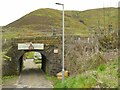
Railway bridge over Frieldhurst Road
The road name is not a typo: Frieldhurst (not Fieldhurst) is the name of a large house higher up this road. With a height limit of 8ft 3in under the narrow bridge, anyone moving in or out of this area must have to use small vans!
Cornholme station was immediately to the right of this bridge but closed in 1938.
Image: © Stephen Craven
Taken: 2 May 2022
0.01 miles
2
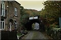
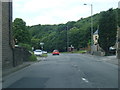
Frieldhurst Road, Cornholme
Ascending away from Burnley Road, - approaching a bridge that carries the Burnley/Todmorden railway.
Image: © Chris Heaton
Taken: 25 Oct 2022
0.02 miles
4
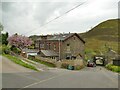
Ingfield Terrace
A row of houses, possibly built for railway workers at the nearby Cornholme station?
Image: © Stephen Craven
Taken: 2 May 2022
0.03 miles
5
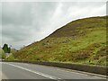
Ruined enclosure on the hillside
This square enclosure of about 500 square metres is shown on older maps but not labelled. A sheepfold would be the obvious use but the location doesn't look very suitable.
Image: © Stephen Craven
Taken: 2 May 2022
0.05 miles
7
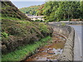
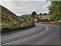
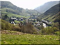
River Calder at Vale
The River Calder with the A646 running alongside it. The Calder rises a few kilometres to the west, on Heald Moor in Lancashire. It then flows east into West Yorkshire through green countryside and former woollen-mill villages and towns before joining the River Aire near Castleford.
Image: © David Dixon
Taken: 15 Sep 2020
0.06 miles
8
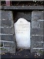
Old milestone
The 2 mile from Todmorden stone on the north sie of the A646 in Cornholme was painted in 2010 but the legend was not picked out. Set into its own recess in the stone wall the white paint has lasted. Grade II listed 339050.
Image: © Robert Glover
Taken: 13 Oct 2020
0.07 miles
10
Modern houses on Burnley Road
They are built on the site of a former mill building, and the one shown here has a datestone 2008 with the initials GNG. It had a 'sold' sign outside.
Image: © Stephen Craven
Taken: 2 May 2022
0.07 miles