IMAGES TAKEN NEAR TO
Halling Place, TODMORDEN, OL14 7LE
Introduction
This page details the photographs taken nearby to Halling Place, OL14 7LE by members of the Geograph project.
The Geograph project started in 2005 with the aim of publishing, organising and preserving representative images for every square kilometre of Great Britain, Ireland and the Isle of Man.

There are currently over 7.5m images from over14,400 individuals and you can help contribute to the project by visiting https://www.geograph.org.uk
Image Map
Images are licensed for reuse under creativecommons.org/licenses/by-sa/2.0
Notes
- Clicking on the map will re-center to the selected point.
- The higher the marker number, the further away the image location is from the centre of the postcode.
Image Listing (427 Images Found)
Images are licensed for reuse under creativecommons.org/licenses/by-sa/2.0
Image
Details
Distance
1
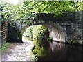
Rochdale Canal, near Halling Place
Image: © Alexander P Kapp
Taken: 17 Aug 2009
0.00 miles
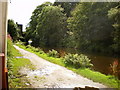
2
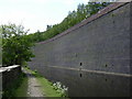
Rochdale Canal
In the trees on the left you can see the start of the "Great Wall of Todmorden" which was built using millions of bricks as a railway embankment
Image: © Robert Wade
Taken: 27 Aug 2009
0.01 miles
3
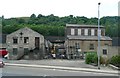
Industrial Buildings, Foundry Street, Todmorden
Was the foundry on this site? The large-scale OS map captions the building on the left as 'Works' and the one on the right, including the burnt-out part where the excavator is, and 'Warehouse'. It seems that the gap between two separate buildings had been filled by constructing a roof over it, but that roof has been destroyed by fire. The building to the right of the lamp-post is captioned "El Sub Sta" (Electricity sub-station).
Image: © Humphrey Bolton
Taken: 26 Jun 2010
0.01 miles
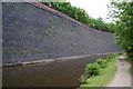
5
The "Great Wall of Todmorden"
The railway is carried on top of this huge wall above the Rochdale canal.
Image: © Robert Wade
Taken: 31 May 2008
0.03 miles
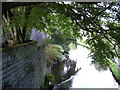
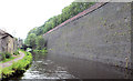
6
A retaining wall by the Rochdale Canal
This is a huge wall, and this shot only shows a short length of it. The railway is at the top, but I don't know whether it is the railway or canal authority which is responsible for it.
Image: © Bill Boaden
Taken: 12 Jun 2010
0.03 miles
7

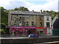
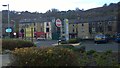
"Barearts" Brewery and Art Gallery, 110 Rochdale Road. Todmorden
The Todmorden in Bloom working group have been meeting since January 2000. Our main aims are to
Clean up the town, and encourage a sense of pride and community spirit
Establish key areas of planting with a growing emphasis on perennial and sustainable planting
Enthuse the whole community to burst into bloom
http://www.todmordeninbloom.ik.com/p_aboutus1.ikml
Image: © Robert Wade
Taken: 18 Aug 2010
0.03 miles
8
Todmorden Canal Railway Embankment Wall
Rochdale Canal near Todmorden. This huge brick wall supports the railway embankment above the canal (to the right of the shot)
Image: © Mike Todd
Taken: 15 Jun 2011
0.04 miles
9
Rochdale Road, Todmorden
A view from a Morrison's supermarket carpark exit towards Rochdale Road in Todmorden, West Yorkshire, England.
Image: © Steven Haslington
Taken: 26 Oct 2014
0.04 miles