IMAGES TAKEN NEAR TO
Sourhall Court, TODMORDEN, OL14 7JT
Introduction
This page details the photographs taken nearby to Sourhall Court, OL14 7JT by members of the Geograph project.
The Geograph project started in 2005 with the aim of publishing, organising and preserving representative images for every square kilometre of Great Britain, Ireland and the Isle of Man.

There are currently over 7.5m images from over14,400 individuals and you can help contribute to the project by visiting https://www.geograph.org.uk
Image Map
Images are licensed for reuse under creativecommons.org/licenses/by-sa/2.0
Notes
- Clicking on the map will re-center to the selected point.
- The higher the marker number, the further away the image location is from the centre of the postcode.
Image Listing (20 Images Found)
Images are licensed for reuse under creativecommons.org/licenses/by-sa/2.0
Image
Details
Distance
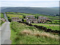
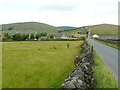
2
Pennine style
A landscape view from the Todmorden Centenary Way under Flower Scar Hill. Sourhall Cottages are down the hill in the foreground, whilst Stoodley Pike stands as a sentinel overlooking Withens Moor.
Image: © Bobby Clegg
Taken: 19 Feb 2013
0.02 miles
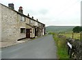
3
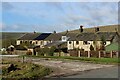
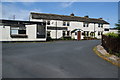
Sourhall Cottages
Row of cottages in the hamlet of Sourhall - a community surrounded by moorland and upland pastures near Todmorden
Image: © Chris Heaton
Taken: 11 Apr 2023
0.04 miles
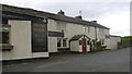
4
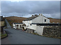
Country Friends
This is what the pub is called now (2008). My OS Street Atlas for West Yorkshire (2000) has it as "The Sourhall". Dr. Neil Clifton's photo of 1987 can be seen here Image where it has another name. Nothing much else changes in these parts over the years.
Image: © michael ely
Taken: 14 Mar 2008
0.04 miles
5
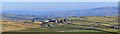
Parkin Lane, Todmorden
The hamlet could be named Sourhall as the terrace houses in the centre of the view are Sourhall Cottages on Sourhall Road. These were originally Peel Mill, and became an Isolation Hospital in 1874 which lasted until 1949 (see http://www.todmordenandwalsden.co.uk/ ). The white public house building was Sour Hall on the 1848 six-inch map and has been called 'The Sourhall', the Olde Dog and Partridge and currently the Country Friends. There do not seem to have been enough friends, however, as the pub looks very neglected and probably closed. Tower Causeway continues straight forward, unfenced over Lower Moor.
Image: © Humphrey Bolton
Taken: 13 Jul 2010
0.04 miles
6
Sourhall Cottages
These were Peel Mill, presumably weavers' cottages joined together.
Image: © Humphrey Bolton
Taken: 13 Jul 2010
0.04 miles
7
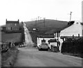
The 'Olde Dog and Partridge' and Tower Causeway
Areas of the Pennines such as this are virtually unvisited by tourists and are unknown even to many who live within a few miles. This location is reached with some difficulty from Todmorden by a road which ascends behind the photographer. A lane on the left leads to Clough Foot and then Bacup, while Tower Causeway is the straight road ahead to Bearnshaw Tower and then by a precipitous descent to Portsmouth. A word of warning to those who would explore such areas: some roads coloured yellow on the map are derelict and unmotorable except in a 4x4, having not been repaired since the 1930s.
Image: © Dr Neil Clifton
Taken: 30 Dec 1987
0.04 miles
8
Country Friends, Sourhall
Known locally as "The Sourhall" it used to be "The Dog and Partridge" and before that "The Last Shift" a very popular local venue which has since fallen on hard times and was closed when we visited
Image: © Robert Wade
Taken: 7 Jun 2009
0.05 miles
9
Country Friends at Sourhall Cottages
A country pub that won't be opening again in the near future.
Image: © Bill Boaden
Taken: 9 Jul 2011
0.06 miles
10
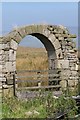
Remains of barn doorway and moorland
Just off Parkin Lane, below Lower Hill
Image: © Phil Berry
Taken: 4 Sep 2005
0.06 miles