IMAGES TAKEN NEAR TO
Stones Lane, TODMORDEN, OL14 7JG
Introduction
This page details the photographs taken nearby to Stones Lane, OL14 7JG by members of the Geograph project.
The Geograph project started in 2005 with the aim of publishing, organising and preserving representative images for every square kilometre of Great Britain, Ireland and the Isle of Man.

There are currently over 7.5m images from over14,400 individuals and you can help contribute to the project by visiting https://www.geograph.org.uk
Image Map
Images are licensed for reuse under creativecommons.org/licenses/by-sa/2.0
Notes
- Clicking on the map will re-center to the selected point.
- The higher the marker number, the further away the image location is from the centre of the postcode.
Image Listing (5 Images Found)
Images are licensed for reuse under creativecommons.org/licenses/by-sa/2.0
Image
Details
Distance

2
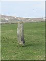
Standing Stone at Stones Lane, Todmorden
The smallest of the three standing stones adjacent to Stones Lane, Todmorden.
Image: © Catherine Chatham
Taken: 12 Mar 2023
0.10 miles
3
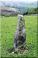
Standing Stone No.2 at Stones
A listed stone possibly prehistoric off Stones Lane. There are reportedly another 3 in the area but only No.1. is also listed. Midgelden Brook is in the valley beyond
Image: © Kevin Waterhouse
Taken: 18 May 2020
0.11 miles
4
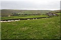
Speke Edge
Speke Edge Farm to right, Stones Grange Farm to left, from an indistinct footpath connecting Parkin Lane and the Calderdale Way.
Image: © Dave Dunford
Taken: 11 Sep 2011
0.12 miles
5
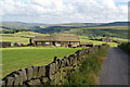
Speke Edge Farm
The road is Stones Lane which goes to the hamlet of Stones and then peters out. The view continues past Calderdale towards the Roch valley and Blackstone Edge.
Image: © Bill Boaden
Taken: 9 Jul 2011
0.15 miles