IMAGES TAKEN NEAR TO
Bacup Road, TODMORDEN, OL14 7HG
Introduction
This page details the photographs taken nearby to Bacup Road, OL14 7HG by members of the Geograph project.
The Geograph project started in 2005 with the aim of publishing, organising and preserving representative images for every square kilometre of Great Britain, Ireland and the Isle of Man.

There are currently over 7.5m images from over14,400 individuals and you can help contribute to the project by visiting https://www.geograph.org.uk
Image Map
Images are licensed for reuse under creativecommons.org/licenses/by-sa/2.0
Notes
- Clicking on the map will re-center to the selected point.
- The higher the marker number, the further away the image location is from the centre of the postcode.
Image Listing (35 Images Found)
Images are licensed for reuse under creativecommons.org/licenses/by-sa/2.0
Image
Details
Distance
3

Postbox on Bacup Road
Postbox No. OL14 152.
See Image] for context.
Image: © JThomas
Taken: 18 Oct 2018
0.03 miles
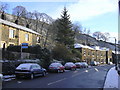
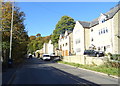
4

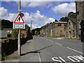
Houses on Bacup Road (A681)
Showing position of Postbox No. OL14 152.
See Image] for postbox.
Image: © JThomas
Taken: 18 Oct 2018
0.04 miles
5
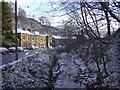
Midgelden Brook, Bacup Road, Todmorden, West Yorkshire
The brook is undergoing a multi million pound clean up
Image: © Robert Wade
Taken: 27 Nov 2010
0.05 miles
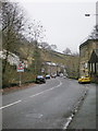
8
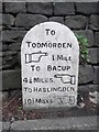
Old Milestone by the A681, Bacup Road, Gauxholme
Carved stone post by the A681, in parish of TODMORDEN (CALDERDALE District), Bacup Road; Gauxholme, opposite No. 77, set in narrow kerb, back to drystone wall, on North side of road. Todmorden round top, erected by the Todmorden turnpike trust in the 18th/19th century.
Inscription reads:-
TO
TODMORDEN
{pointing hand} 1 MILE
TO BACUP
4¼ MILES {pointing hand}
TO HASLINGDEN
10½ MILES {pointing hand}
Grade II listed. List Entry Number: 1133777
https://historicengland.org.uk/listing/the-list/list-entry/1133777
Milestone Society National ID: YW_TOBP01.
Image: © CM & AK
Taken: 5 Sep 2002
0.08 miles
9
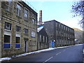
Stoneswood Mill (Inchfield Pasture Cotton Mill) Bacup Road, Todmorden
Image: © Robert Wade
Taken: 27 Nov 2010
0.08 miles
10
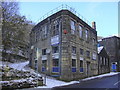
Stoneswood Mill, Bacup Road, Todmorden
Stoneswood, or more properly, the Inchfield Pasture Cotton Mill, is one of the very early cotton carding and spinning mills. It is situated in the Dulesgate valley (Bacup Road), obtaining its power from the Dulesgate stream. The original mill would have been a small affair with a water wheel. The present mill consists of two adjacent but separate buildings. The higher of the two is the older, and would have replaced the original mill. The lower building was erected much later, about 1900. Both buildings are 3 storeys high. The space between the two is used for car parking and as a loading bay.
Researched, recorded and referenced by Mrs Sheila Wade
Hebden Bridge WEA Local History Group
Image: © Robert Wade
Taken: 27 Nov 2010
0.08 miles