IMAGES TAKEN NEAR TO
Rockery Lane, OL14 7BT
Introduction
This page details the photographs taken nearby to Rockery Lane, OL14 7BT by members of the Geograph project.
The Geograph project started in 2005 with the aim of publishing, organising and preserving representative images for every square kilometre of Great Britain, Ireland and the Isle of Man.

There are currently over 7.5m images from over14,400 individuals and you can help contribute to the project by visiting https://www.geograph.org.uk
Image Map
Images are licensed for reuse under creativecommons.org/licenses/by-sa/2.0
Notes
- Clicking on the map will re-center to the selected point.
- The higher the marker number, the further away the image location is from the centre of the postcode.
Image Listing (44 Images Found)
Images are licensed for reuse under creativecommons.org/licenses/by-sa/2.0
Image
Details
Distance
2

Old milestone
Many of the stone milestones around Todmorden were painted in 2010. Nearly 17 miles of roads around the town were turnpiked in 1771. This stone on the A646 Burnley Road near the entrance to Scaitcliffe Hall has had its white paint washed away by rain with just the black lettering remaining in 2020. It is Grade II listed 339043.
Image: © Robert Glover
Taken: 26 Sep 2020
0.03 miles
3

Old Milestone by the A646, Burnley Road, Todmorden parish
Carved stone post by the A646, in parish of TODMORDEN (CALDERDALE District), Burnley Road, North of entrance to Scaitcliffe Hall, West of Stoney Royd Lane, North of Todmorden High School, on West side of road. Todmorden rolltop, erected by the Todmorden turnpike trust in the 18th/19th century.
Inscription reads:-
TO
TODMORDEN
1 MILE {<-hand}
{line}
TO BURNLEY
{hand->} 8¼ MILES
{line}
Grade II listed.
List Entry Number: 1133754 https://historicengland.org.uk/listing/the-list/list-entry/1133754
Milestone Society National ID: YW_TOBL01.
Image: © C Minto
Taken: 6 May 2004
0.03 miles
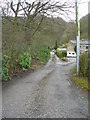
7
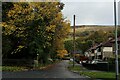
Stoney Royd Lane, Todmorden
Adopted by the Calderdale Way long distance footpath - seen here leaving Burnley Road, before a steep ascent towards Whirlow Common
Image: © Chris Heaton
Taken: 25 Oct 2022
0.06 miles
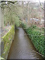
10
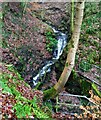
Scaitcliffe Clough
With the new debris trap at its foot
Image: © Kevin Waterhouse
Taken: 18 Dec 2021
0.10 miles