IMAGES TAKEN NEAR TO
Claremont Terrace, TODMORDEN, OL14 6UZ
Introduction
This page details the photographs taken nearby to Claremont Terrace, OL14 6UZ by members of the Geograph project.
The Geograph project started in 2005 with the aim of publishing, organising and preserving representative images for every square kilometre of Great Britain, Ireland and the Isle of Man.

There are currently over 7.5m images from over14,400 individuals and you can help contribute to the project by visiting https://www.geograph.org.uk
Image Map
Images are licensed for reuse under creativecommons.org/licenses/by-sa/2.0
Notes
- Clicking on the map will re-center to the selected point.
- The higher the marker number, the further away the image location is from the centre of the postcode.
Image Listing (107 Images Found)
Images are licensed for reuse under creativecommons.org/licenses/by-sa/2.0
Image
Details
Distance
1
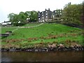
Four-storey housing at Warland
Probably built as two two-storey terraces on top of each other, with lower street access on this side, and higher street access on the other.
Image: © Christine Johnstone
Taken: 6 May 2014
0.01 miles
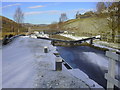
2
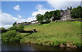
Warland
Viewed from below by the Rochdale Canal. An aqueduct crosses the canal to the left, carrying water from Warland Reservoir.
Image: © Bill Boaden
Taken: 12 Jun 2010
0.01 miles
3
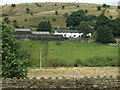
Cottages at Warland
Viewed from the A6033 Littleborough to Todmorden road, these cottages are overlooking the Rochdale Canal.
Image: © Colin Pyle
Taken: 19 Aug 2008
0.03 miles
5
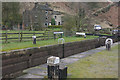
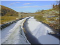
Warland Upper Lock, Rochdale Canal
This lock is just in Yorkshire, although the county boundary with Lancashire is marked by a stone just above the top gate. This is the last lock heading up before the summit level is reached.
Image: © Stephen McKay
Taken: 30 Mar 2009
0.03 miles
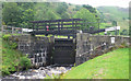
6
Warland Upper Lock No 35, Rochdale Canal, Warland, Littleborough-Todmorden
Image: © Robert Wade
Taken: 27 Nov 2010
0.03 miles
7
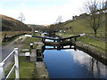
Rochdale Canal: Warland Upper Lock No 35
Looking north,i.e. towards Todmorden. Warland Upper is the second highest lock on the 'Yorkshire' end on the canal. This canal has now been fully reopened.
Image: © Dr Neil Clifton
Taken: 18 Mar 2011
0.04 miles
8
Wanland Upper Lock 35 from below
Rochdale Canal
Image: © Mike Todd
Taken: 15 Jun 2011
0.04 miles
9
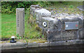
County Boundary stone
Rochdale Canal - marks boundary between Yorkshire and Lancashire between Bridge 41 and Lock 35
Image: © Mike Todd
Taken: 15 Jun 2011
0.04 miles
10

Warland Upper Lock No 35, Rochdale Canal
Image: © Alexander P Kapp
Taken: 30 May 2007
0.04 miles