IMAGES TAKEN NEAR TO
Warland Gate End, TODMORDEN, OL14 6UP
Introduction
This page details the photographs taken nearby to Warland Gate End, OL14 6UP by members of the Geograph project.
The Geograph project started in 2005 with the aim of publishing, organising and preserving representative images for every square kilometre of Great Britain, Ireland and the Isle of Man.

There are currently over 7.5m images from over14,400 individuals and you can help contribute to the project by visiting https://www.geograph.org.uk
Image Map
Images are licensed for reuse under creativecommons.org/licenses/by-sa/2.0
Notes
- Clicking on the map will re-center to the selected point.
- The higher the marker number, the further away the image location is from the centre of the postcode.
Image Listing (122 Images Found)
Images are licensed for reuse under creativecommons.org/licenses/by-sa/2.0
Image
Details
Distance
1
Warland
The boundary post marks the border between Lancashire and Yorkshire. Perhaps this has some connection with the name of this settlement? A close-up of the county boundary stone can be seen here Image
Image: © David Stowell
Taken: Unknown
0.01 miles
2
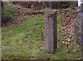
County Boundary Stone
Erected in 1990 on the east bank of the Rochdale Canal at Warland Upper Lock. The boundary stone in its geographic context can be seen here Image
Image: © michael ely
Taken: 17 Nov 2006
0.01 miles
3
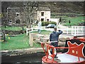
Rochdale Canal, Warland
Looking south in the direction of Littleborough from the swing bridge over the canal.
Image: © michael ely
Taken: 17 Nov 2006
0.01 miles
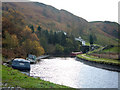
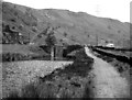
4
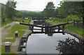
Warland Upper Lock no.35
Looking along the Rochdale Canal towards Todmorden. Traffic on the A6033 can be seen left of shot.
Image: © michael ely
Taken: 17 Nov 2006
0.01 miles
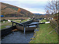
5
Warland Upper Lock No 35, Rochdale Canal
This is taken looking southwards, (actually slightly south-eastwards) and shows the unrestored lock as it was in 1974. This lock is in the West Riding of Yorkshire, but the County boundary crosses just further away than the lock, and the white house seen to the right, which is actually the lock cottage at the next lock (Long Lees Lock No 36) is in Lancashire.
Image: © Dr Neil Clifton
Taken: 30 May 1974
0.01 miles
6
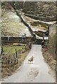
Warland Gate End
This Lane off the A6033 is called Warland Gate End.
A lot of people think the whole hamlet is called that rather than just the Lane.
Often there are sheep wandering around as this one was
Image: © Gillie Rhodes
Taken: 13 Feb 2021
0.01 miles
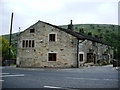
8
Warland
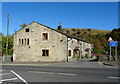
Terrace of houses at Warland.
Image: © Peter McDermott
Taken: 5 May 2018
0.01 miles
10
Wanland Upper Lock 35 from above
Rochdale Canal
Image: © Mike Todd
Taken: 15 Jun 2011
0.03 miles