IMAGES TAKEN NEAR TO
Lumbutts Road, TODMORDEN, OL14 6JW
Introduction
This page details the photographs taken nearby to Lumbutts Road, OL14 6JW by members of the Geograph project.
The Geograph project started in 2005 with the aim of publishing, organising and preserving representative images for every square kilometre of Great Britain, Ireland and the Isle of Man.

There are currently over 7.5m images from over14,400 individuals and you can help contribute to the project by visiting https://www.geograph.org.uk
Image Map
Images are licensed for reuse under creativecommons.org/licenses/by-sa/2.0
Notes
- Clicking on the map will re-center to the selected point.
- The higher the marker number, the further away the image location is from the centre of the postcode.
Image Listing (33 Images Found)
Images are licensed for reuse under creativecommons.org/licenses/by-sa/2.0
Image
Details
Distance
1
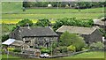
Swineshead Farm
View from Lower Knowl
Image: © Kevin Waterhouse
Taken: 7 Jun 2021
0.02 miles
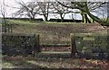
2
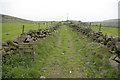
Swineshead Lane (bridleway)
Looking towards Swineshead Farm on Lumbutts Road
Image: © Phil Champion
Taken: 6 May 2007
0.08 miles
3
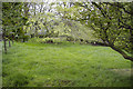
Shoebroad (Shewbread) Quaker Burial Ground
A quiet and contemplative spot overlooking Todmorden. Photo taken from the adjacent Shoebroad Lane. The entrance shown at http://www.geograph.org.uk/photo/339264 is to the right. Burials commenced here in 1690. A history of the Society of Friends in Todmorden can be found at http://freepages.genealogy.rootsweb.com/~todmordenandwalsden/quakers.htm
Image: © Phil Champion
Taken: 6 May 2007
0.17 miles
4
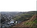
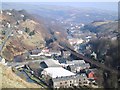
Gauxholme and Walsden
Taken from Pexwood Road with Gauxholme below and Walsden further along the valley, the path twisting over the opposite hillside is the old pack horse road
Image: © Ian Hargreaves
Taken: 15 Feb 2007
0.18 miles
5
Gauxholme
Taken on the path up to Naze, showing Gauxholme down below, Todmorden is seen further along the valley.
Image: © Ian Hargreaves
Taken: 1 May 2005
0.18 miles
6
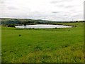
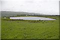
View Of Small Reservoir
Grassland in front of a small reservoir high above Todmorden.
Image: © Rude Health
Taken: 6 Aug 2013
0.18 miles
8
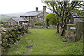
Top of the Rough from Moor Lane
The last farm before the open moor
Image: © Phil Champion
Taken: 6 May 2007
0.19 miles
9
Shewbread Quaker Burial Ground
Walled enclosure on Shoebroad Lane on the hillside high above Todmorden. A stone tablet near the gate bears the inscription "Shewbread Quaker Burial Ground c.1668". The "Shoebroad" of Shoebroad Lane is apparently a corruption of the biblical "shewbread", the table where God speaks to man and nourishes him.
Image: © Paul Glazzard
Taken: 8 Mar 2007
0.20 miles
10

Stone
In the wall at Shewbread, Quaker Burial Ground c1668
Image: © Alexander P Kapp
Taken: 15 Oct 2008
0.20 miles