IMAGES TAKEN NEAR TO
Stoodley Close, TODMORDEN, OL14 6HY
Introduction
This page details the photographs taken nearby to Stoodley Close, OL14 6HY by members of the Geograph project.
The Geograph project started in 2005 with the aim of publishing, organising and preserving representative images for every square kilometre of Great Britain, Ireland and the Isle of Man.

There are currently over 7.5m images from over14,400 individuals and you can help contribute to the project by visiting https://www.geograph.org.uk
Image Map
Images are licensed for reuse under creativecommons.org/licenses/by-sa/2.0
Notes
- Clicking on the map will re-center to the selected point.
- The higher the marker number, the further away the image location is from the centre of the postcode.
Image Listing (31 Images Found)
Images are licensed for reuse under creativecommons.org/licenses/by-sa/2.0
Image
Details
Distance
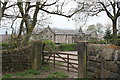
1
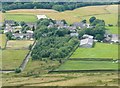
Stoodley Grange from Stoodley Pike, Langfield
This shows the former hospital buildings. Lee Side Farm was there before the hospital, and the suburban-style development to the left is a mid-20C addition. The driveway is the public footpath, whilst the strip along the eastern boundary of the plantation is a footpath that was closed when the hospital was built c.1892 (see Image).
Image: © Humphrey Bolton
Taken: 21 Jul 2012
0.05 miles

3
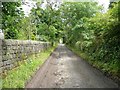
Footpath from Lee Bottom Road to London Road, Langfield
This has been widened as a driveway to Lee Side Farm, Lower Greave and a row of newer houses called Fellside. It makes an easy approach to the climb up Stoodley Pike.
Image: © Humphrey Bolton
Taken: 21 Jul 2012
0.07 miles
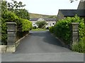
5
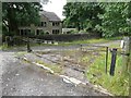
Gateway to Lee Side Farm
An exceptionally wide gate!
Image: © Humphrey Bolton
Taken: 21 Jul 2012
0.09 miles
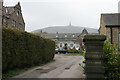
8
Entrance to Stoodley Grange
This was the Fielden Joint Hospital (Infectious Diseases). I have been informed tat it was later a hospital for children with learning disabilities, and that when it was closed most of the children were moved to Stansfield View.
Despite the name, it seems that there was never a private house here. The hospital was founded by the Fielden family, mill-owners and philanthropists of Todmorden. The buildings are dated 1892 and 1905, now converted to houses. New houses have been built on the site of prefabricated buildings.
Image: © Humphrey Bolton
Taken: 21 Jul 2012
0.11 miles
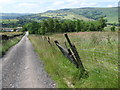
9
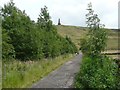
Footpath from Lee Bottom Road to London Road
The Stoodley Pike Monument beckons.
Image: © Humphrey Bolton
Taken: 21 Jul 2012
0.12 miles
10

Houses at Stoodley Grange, Langfield
This was the former administrative block. The nurses’ home was adjacent. See Image
Image: © Humphrey Bolton
Taken: 21 Jul 2012
0.12 miles