IMAGES TAKEN NEAR TO
Todmorden Old Road, BACUP, OL13 8RU
Introduction
This page details the photographs taken nearby to Todmorden Old Road, OL13 8RU by members of the Geograph project.
The Geograph project started in 2005 with the aim of publishing, organising and preserving representative images for every square kilometre of Great Britain, Ireland and the Isle of Man.

There are currently over 7.5m images from over14,400 individuals and you can help contribute to the project by visiting https://www.geograph.org.uk
Image Map
Images are licensed for reuse under creativecommons.org/licenses/by-sa/2.0
Notes
- Clicking on the map will re-center to the selected point.
- The higher the marker number, the further away the image location is from the centre of the postcode.
Image Listing (16 Images Found)
Images are licensed for reuse under creativecommons.org/licenses/by-sa/2.0
Image
Details
Distance
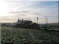
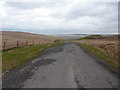
2
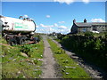
Bridleway at Heald Top Farm, Cliviger
The abandoned tanker has 'Enviri Care' on the side!
Image: © Humphrey Bolton
Taken: 20 Jun 2019
0.02 miles
3
Presumed Boundary Stone
At Heald Top Farm
Image: © Kevin Waterhouse
Taken: 30 Aug 2020
0.02 miles
4
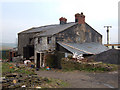
Heald Top Farm. Sharneyford
Situated on the line of the Rossendale Way. Not sure if this farm is derelict. Definitely not a "Grand Design", more a "Suitable Case for Treatment". Would you want to live here?
Image: © michael ely
Taken: 4 May 2006
0.04 miles
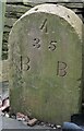
5
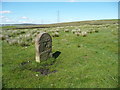
Boundary stone at Heald Top
This is on the boundary between Todmorden and Bacup, and there is a 'T' on the other side, but why a 'D'on this side? Before Bacup became a civil parish, it was in Brandwood Higher End, so that doesn't help. However the Cliviger Gorge Packhorse Trails Circuit article http://ures-burnley.org.uk/wp-content/uploads/2015/04/Cliviger-Gorge-Packhorse-Trails-Circuit.pdf states that the T and D on a similar stone to the north-west stand for Sir John Townley of Burnley and Dearden of Rochdale, and was erected by Townley in 1536.
Image: © Humphrey Bolton
Taken: 20 Jun 2019
0.09 miles
6
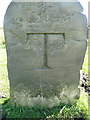
Boundary stone on Heald Top, Todmorden face
This is the other side of the stone shown in Image T is for Sir John Toawnley of Burnley, who erected the stone in 1536 to mark the boundary of his land.
Image: © Humphrey Bolton
Taken: 20 Jun 2019
0.09 miles
8
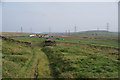
Path approaching Heald Top Farm
This is getting near to a uniquely scruffy part of the moor above Sharneyford.
Image: © Bill Boaden
Taken: 29 Apr 2011
0.10 miles
10
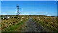
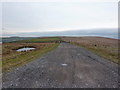
Track to Hill Top Mine
Old road to the last mine around the Heald Moor area
Image: © Kevin Waterhouse
Taken: 23 Sep 2022
0.13 miles